Izobil’noye geodata
Izobil’noye (Republic of Crimea) is a populated place; located in Ukraine in Europe/Simferopol (GMT+3) time zone. With population of 2,333 people, there are 1056 cities with bigger population in this country. Compared to other cities in Ukraine, 97.1% of cities are located further ↑North; 70.8% of cities are located further ←West and 75.7% of cities have lower elevation than Izobil’noye. Note1


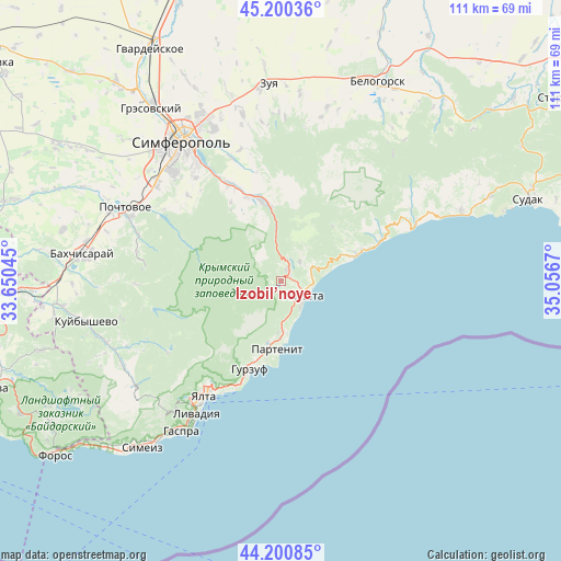
Izobil’noye GPS coordinates[2]
44° 42' 9.936" North, 34° 21' 12.852" East
| Map corner | latitude | longitude |
|---|---|---|
| Upper-left | 45.20036°, | 33.65045° |
| Center: | 44.70276°, | 34.35357° |
| Lower-right: | 44.20085°, | 35.0567° |
| Map W x H: | 111.1×111.1 km | = 69×69mi |
| max Lat: | 52.18903° ⇑97.1% North |
| Izobil’noye: | 44.70276° |
| min Lat: | ⇓2.9% South 44.39214° |
| min Long | Izobil’noye | max Long |
| 22.20555° | 34.35357° | 40.13222° |
| W 70.8%⇐ | ⇒29.2% E |
Elevation
Elevation of Izobil’noye is 228 m = 748 ft, and this is 72.2 m = 237 ft above average elevation for this country.
| Max E: |
886 m = 2907 ft | 24.3% |
| Izobil’noye | 228 m 748 ft | |
| Avg. | 155.8 m = 511 ft | |
Min E: |
-3 m = -10 ft | 75.7% |
See also: Ukraine elevation on elevation.city.
Geographical zone
Izobil’noye is located in North temperate zone (between Tropic of Cancer and the Arctic Circle). Distance of this Northern Tropic circle is 2364.6 km =1469.3 mi to South.| Distance of | km | miles | from Izobil’noye |
|---|---|---|---|
| North Pole | 5036.6 | 3129.6 | to North |
| Arctic Circle | 2430.7 | 1510.4 | to North |
| Tropic Cancer | 2364.6 | 1469.3 | to South |
| Equator | 4970.5 | 3088.5 | to South |


Nearby cities:
15 places around Izobil’noye: (largest is in red/bold)
• Alushta
5.3 km =3.3 mi,  122°
122°
• Gurzuf
18.4 km =11.4 mi,  198°
198°
• Krasnokamenka
16.3 km =10.1 mi, 198°
• Krasnolesye
17.4 km =10.8 mi,  326°
326°
• Luchistoye
5.3 km =3.3 mi,  44°
44°
• Malorechenskoye
17.3 km =10.7 mi,  68°
68°
• Maly Mayak
10 km =6.2 mi,  174°
174°
• Nizhnyaya Kutuzovka
2.2 km =1.4 mi, 73°
• Partenit
13.9 km =8.6 mi,  182°
182°
• Pereval'noye
16.5 km =10.3 mi,  348°
348°
• Rybach'e
20.7 km =12.9 mi, 67°
• Solnechnogorskoye
15.5 km =9.6 mi, 71°
• Verkhnyaya Kutuzovka
2.5 km =1.6 mi,  31°
31°
• Zaprudnoye
12.6 km =7.8 mi,  193°
193°
• Zarechnoye
17.9 km =11.1 mi,  336°
336°
Sources, notices
• [Note1] Compared only with cities in Ukraine existing in our database
• [Src1] Map data: © OpenStreetMap contributors (CC-BY-SA)
• [Src2] Other city data from geonames.org with taken over terms of usage.
• [Src3] Geographical zone / Annual Mean Temperature by Robert A. Rohde @ Wikipedia
