Zaprudnoye geodata
Zaprudnoye (Republic of Crimea) is a populated place; located in Ukraine in Europe/Simferopol (GMT+3) time zone. With population of 788 people, there are 1490 cities with bigger population in this country. Compared to other cities in Ukraine, 98% of cities are located further ↑North; 69.9% of cities are located further ←West and 94.8% of cities have lower elevation than Zaprudnoye. Note1


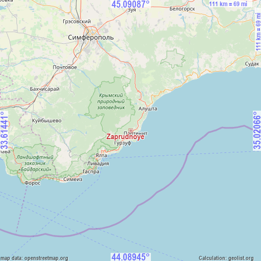
Zaprudnoye GPS coordinates[2]
44° 35' 32.352" North, 34° 19' 3.108" East
| Map corner | latitude | longitude |
|---|---|---|
| Upper-left | 45.09087°, | 33.61441° |
| Center: | 44.59232°, | 34.31753° |
| Lower-right: | 44.08945°, | 35.02066° |
| Map W x H: | 111.3×111.3 km | = 69.2×69.2mi |
| max Lat: | 52.18903° ⇑98% North |
| Zaprudnoye: | 44.59232° |
| min Lat: | ⇓2% South 44.39214° |
| min Long | Zaprudnoye | max Long |
| 22.20555° | 34.31753° | 40.13222° |
| W 69.9%⇐ | ⇒30.1% E |
Elevation
Elevation of Zaprudnoye is 360 m = 1181 ft, and this is 204.2 m = 670 ft above average elevation for this country.
| Max E: |
886 m = 2907 ft | 5.2% |
| Zaprudnoye | 360 m 1181 ft | |
| Avg. | 155.8 m = 511 ft | |
Min E: |
-3 m = -10 ft | 94.8% |
See also: Ukraine elevation on elevation.city.
Geographical zone
Zaprudnoye is located in North temperate zone (between Tropic of Cancer and the Arctic Circle). Distance of this Northern Tropic circle is 2352.3 km =1461.7 mi to South.| Distance of | km | miles | from Zaprudnoye |
|---|---|---|---|
| North Pole | 5048.9 | 3137.2 | to North |
| Arctic Circle | 2443 | 1518 | to North |
| Tropic Cancer | 2352.3 | 1461.7 | to South |
| Equator | 4958.2 | 3080.9 | to South |


Nearby cities:
15 places around Zaprudnoye: (largest is in red/bold)
• Alushta
11.9 km =7.4 mi,  37°
37°
• Gurzuf
6 km =3.7 mi,  211°
211°
• Izobil’noye
12.6 km =7.8 mi,  13°
13°
• Krasnokamenka
3.9 km =2.4 mi,  215°
215°
• Luchistoye
17.3 km =10.7 mi,  22°
22°
• Maly Mayak
4.4 km =2.7 mi,  57°
57°
• Massandra
13.8 km =8.6 mi,  228°
228°
• Nikita
10.6 km =6.6 mi, 216°
• Nizhnyaya Kutuzovka
13.8 km =8.6 mi, 20°
• Otradnoye
12.9 km =8 mi, 220°
• Partenit
2.7 km =1.7 mi,  126°
126°
• Sovetskoye
12.2 km =7.6 mi,  237°
237°
• Verkhnyaya Kutuzovka
15 km =9.3 mi, 16°
• Vinogradnoye
19.3 km =12 mi, 230°
• Yalta
15.6 km =9.7 mi, 230°
Sources, notices
• [Note1] Compared only with cities in Ukraine existing in our database
• [Src1] Map data: © OpenStreetMap contributors (CC-BY-SA)
• [Src2] Other city data from geonames.org with taken over terms of usage.
• [Src3] Geographical zone / Annual Mean Temperature by Robert A. Rohde @ Wikipedia
