Teplodar geodata
Teplodar (Odesa) is a populated place; located in Ukraine in Europe/Kiev (GMT+3) time zone. With population of 8,502 people, there are 418 cities with bigger population in this country. Compared to other cities in Ukraine, 67.1% of cities are located further ↑North; 66% of cities are located further →East and 68.7% of cities have higher elevation than Teplodar. Note1


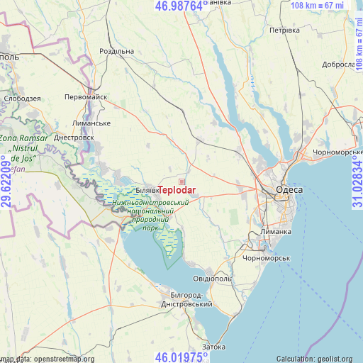
Teplodar GPS coordinates[2]
46° 30' 21.06" North, 30° 19' 30.756" East
| Map corner | latitude | longitude |
|---|---|---|
| Upper-left | 46.98764°, | 29.62209° |
| Center: | 46.50585°, | 30.32521° |
| Lower-right: | 46.01975°, | 31.02834° |
| Map W x H: | 107.6×107.6 km | = 66.9×66.9mi |
| max Lat: | 52.18903° ⇑67.1% North |
| Teplodar: | 46.50585° |
| min Lat: | ⇓32.9% South 44.39214° |
| min Long | Teplodar | max Long |
| 22.20555° | 30.32521° | 40.13222° |
| W 34%⇐ | ⇒66% E |
Elevation
Elevation of Teplodar is 78 m = 256 ft, and this is 77.8 m = 255 ft below average elevation for this country.
| Max E: |
886 m = 2907 ft | 68.7% |
| Avg. | 155.8 m = 511 ft | |
| Teplodar | 78 m = 256 ft | |
Min E: |
-3 m = -10 ft | 31.3% |
See also: Ukraine elevation on elevation.city.
Geographical zone
Teplodar is located in North temperate zone (between Tropic of Cancer and the Arctic Circle). Distance of this North polar circle is 2230.2 km =1385.8 mi to North.| Distance of | km | miles | from Teplodar |
|---|---|---|---|
| North Pole | 4836.1 | 3005 | to North |
| Arctic Circle | 2230.2 | 1385.8 | to North |
| Tropic Cancer | 2565 | 1593.8 | to South |
| Equator | 5171 | 3213.1 | to South |


Nearby cities:
15 places around Teplodar: (largest is in red/bold)
• Bilhorod-Dnistrovskyi
34.6 km =21.5 mi,  176°
176°
• Bilyayivka
8.7 km =5.4 mi,  253°
253°
• Chornomors’k
33.7 km =20.9 mi,  131°
131°
• Krasnosilka
36.7 km =22.8 mi,  69°
69°
• Kryzhanivka
36.5 km =22.7 mi,  80°
80°
• Lymanske
32 km =19.9 mi,  301°
301°
• Mayaky
10.6 km =6.6 mi,  201°
201°
• Odessa
31.3 km =19.4 mi,  95°
95°
• Oleksandrivka
30.8 km =19.1 mi, 129°
• Ovidiopol
29.8 km =18.5 mi,  162°
162°
• Pavlivka
38.3 km =23.8 mi,  317°
317°
• Starokozache
32.1 km =19.9 mi,  234°
234°
• Stepove
28.9 km =18 mi, 319°
• Tayirove
29.4 km =18.3 mi,  122°
122°
• Usatove
25.8 km =16 mi, 83°
Sources, notices
• [Note1] Compared only with cities in Ukraine existing in our database
• [Src1] Map data: © OpenStreetMap contributors (CC-BY-SA)
• [Src2] Other city data from geonames.org with taken over terms of usage.
• [Src3] Geographical zone / Annual Mean Temperature by Robert A. Rohde @ Wikipedia
