Chornyanka geodata
Chornyanka (Kherson) is a populated place; located in Ukraine in Europe/Kiev (GMT+3) time zone. With population of 3,363 people, there are 856 cities with bigger population in this country. Compared to other cities in Ukraine, 66.2% of cities are located further ↑North; 50.4% of cities are located further ←West and 93.7% of cities have higher elevation than Chornyanka. Note1


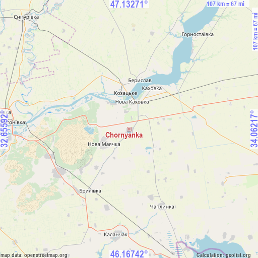
Chornyanka GPS coordinates[2]
46° 39' 7.992" North, 33° 21' 32.544" East
| Map corner | latitude | longitude |
|---|---|---|
| Upper-left | 47.13271°, | 32.65592° |
| Center: | 46.65222°, | 33.35904° |
| Lower-right: | 46.16742°, | 34.06217° |
| Map W x H: | 107.3×107.3 km | = 66.7×66.7mi |
| max Lat: | 52.18903° ⇑66.2% North |
| Chornyanka: | 46.65222° |
| min Lat: | ⇓33.8% South 44.39214° |
| min Long | Chornyanka | max Long |
| 22.20555° | 33.35904° | 40.13222° |
| W 50.4%⇐ | ⇒49.6% E |
Elevation
Elevation of Chornyanka is 14 m = 46 ft, and this is 141.8 m = 465 ft below average elevation for this country.
| Max E: |
886 m = 2907 ft | 93.7% |
| Avg. | 155.8 m = 511 ft | |
| Chornyanka | 14 m = 46 ft | |
Min E: |
-3 m = -10 ft | 6.3% |
See also: Ukraine elevation on elevation.city.
Geographical zone
Chornyanka is located in North temperate zone (between Tropic of Cancer and the Arctic Circle). Distance of this North polar circle is 2213.9 km =1375.7 mi to North.| Distance of | km | miles | from Chornyanka |
|---|---|---|---|
| North Pole | 4819.8 | 2994.9 | to North |
| Arctic Circle | 2213.9 | 1375.7 | to North |
| Tropic Cancer | 2581.3 | 1603.9 | to South |
| Equator | 5187.2 | 3223.2 | to South |


Nearby cities:
15 places around Chornyanka: (largest is in red/bold)
• Askaniya-Nova
44.9 km =27.9 mi,  119°
119°
• Beryslav
21.7 km =13.5 mi,  14°
14°
• Brylivka
30 km =18.6 mi,  212°
212°
• Chaplynka
34.8 km =21.6 mi,  156°
156°
• Dnipryany
12.4 km =7.7 mi,  327°
327°
• Kakhovka
20.4 km =12.7 mi,  28°
28°
• Kalanchak
44.3 km =27.5 mi,  186°
186°
• Kayiry
41.9 km =26 mi,  39°
39°
• Kozachi Laheri
29.7 km =18.5 mi,  281°
281°
• Lyubymivka
23.8 km =14.8 mi, 42°
• Malokakhovka
15.9 km =9.9 mi, 25°
• Nova Kakhovka
11.4 km =7.1 mi,  356°
356°
• Nova Mayachka
11.6 km =7.2 mi,  240°
240°
• Radens’k
34.9 km =21.7 mi,  250°
250°
• Velyki Kopani
34.6 km =21.5 mi, 237°
Sources, notices
• [Note1] Compared only with cities in Ukraine existing in our database
• [Src1] Map data: © OpenStreetMap contributors (CC-BY-SA)
• [Src2] Other city data from geonames.org with taken over terms of usage.
• [Src3] Geographical zone / Annual Mean Temperature by Robert A. Rohde @ Wikipedia
