Chaplynka geodata
Chaplynka (Kherson) is a seat of a second-order administrative division; located in Ukraine in Europe/Kiev (GMT+3) time zone. With population of 10,224 people, there are 352 cities with bigger population in this country. Compared to other cities in Ukraine, 67.6% of cities are located further ↑North; 52.3% of cities are located further ←West and 90.1% of cities have higher elevation than Chaplynka. Note1


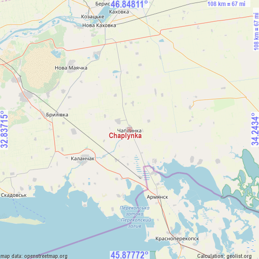
Chaplynka GPS coordinates[2]
46° 21' 54.252" North, 33° 32' 24.972" East
| Map corner | latitude | longitude |
|---|---|---|
| Upper-left | 46.84811°, | 32.83715° |
| Center: | 46.36507°, | 33.54027° |
| Lower-right: | 45.87772°, | 34.2434° |
| Map W x H: | 107.9×107.9 km | = 67×67mi |
| max Lat: | 52.18903° ⇑67.6% North |
| Chaplynka: | 46.36507° |
| min Lat: | ⇓32.4% South 44.39214° |
| min Long | Chaplynka | max Long |
| 22.20555° | 33.54027° | 40.13222° |
| W 52.3%⇐ | ⇒47.7% E |
Elevation
Elevation of Chaplynka is 19 m = 62 ft, and this is 136.8 m = 449 ft below average elevation for this country.
| Max E: |
886 m = 2907 ft | 90.1% |
| Avg. | 155.8 m = 511 ft | |
| Chaplynka | 19 m = 62 ft | |
Min E: |
-3 m = -10 ft | 9.9% |
See also: Ukraine elevation on elevation.city.
Geographical zone
Chaplynka is located in North temperate zone (between Tropic of Cancer and the Arctic Circle). Distance of this North polar circle is 2245.9 km =1395.5 mi to North.| Distance of | km | miles | from Chaplynka |
|---|---|---|---|
| North Pole | 4851.7 | 3014.7 | to North |
| Arctic Circle | 2245.9 | 1395.5 | to North |
| Tropic Cancer | 2549.4 | 1584.1 | to South |
| Equator | 5155.3 | 3203.4 | to South |


Nearby cities:
15 places around Chaplynka: (largest is in red/bold)
• Armyansk
30.8 km =19.1 mi,  157°
157°
• Askaniya-Nova
27 km =16.8 mi,  69°
69°
• Brylivka
30.9 km =19.2 mi,  282°
282°
• Chornyanka
34.8 km =21.6 mi,  336°
336°
• Filatovka
36.7 km =22.8 mi,  149°
149°
• Kalanchak
22.7 km =14.1 mi,  237°
237°
• Nova Kakhovka
45.7 km =28.4 mi, 341°
• Nova Mayachka
35.5 km =22.1 mi,  317°
317°
• Perekop
25.5 km =15.8 mi, 152°
• Pochetnoye
44.7 km =27.8 mi, 157°
• Risovoye
39.4 km =24.5 mi, 162°
• Suvorovo
32.8 km =20.4 mi, 159°
• Tavricheskoye
46.1 km =28.6 mi, 159°
• Velyki Kopani
45.4 km =28.2 mi,  287°
287°
• Vynohradove
46.1 km =28.6 mi,  270°
270°
Sources, notices
• [Note1] Compared only with cities in Ukraine existing in our database
• [Src1] Map data: © OpenStreetMap contributors (CC-BY-SA)
• [Src2] Other city data from geonames.org with taken over terms of usage.
• [Src3] Geographical zone / Annual Mean Temperature by Robert A. Rohde @ Wikipedia
