Koktebel geodata
Koktebel (Republic of Crimea) is a populated place; located in Ukraine in Europe/Simferopol (GMT+3) time zone. With population of 2,807 people, there are 989 cities with bigger population in this country. Compared to other cities in Ukraine, 92.2% of cities are located further ↑North; 82.9% of cities are located further ←West and 96.8% of cities have higher elevation than Koktebel. Note1


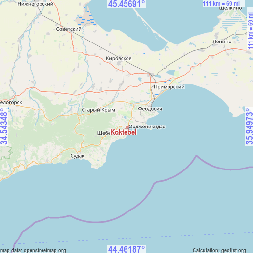
Koktebel GPS coordinates[2]
44° 57' 41.58" North, 35° 14' 47.76" East
| Map corner | latitude | longitude |
|---|---|---|
| Upper-left | 45.45691°, | 34.54348° |
| Center: | 44.96155°, | 35.2466° |
| Lower-right: | 44.46187°, | 35.94973° |
| Map W x H: | 110.6×110.6 km | = 68.7×68.7mi |
| max Lat: | 52.18903° ⇑92.2% North |
| Koktebel: | 44.96155° |
| min Lat: | ⇓7.8% South 44.39214° |
| min Long | Koktebel | max Long |
| 22.20555° | 35.2466° | 40.13222° |
| W 82.9%⇐ | ⇒17.1% E |
Elevation
Elevation of Koktebel is 9 m = 30 ft, and this is 146.8 m = 482 ft below average elevation for this country.
| Max E: |
886 m = 2907 ft | 96.8% |
| Avg. | 155.8 m = 511 ft | |
| Koktebel | 9 m = 30 ft | |
Min E: |
-3 m = -10 ft | 3.2% |
See also: Ukraine elevation on elevation.city.
Geographical zone
Koktebel is located in North temperate zone (between Tropic of Cancer and the Arctic Circle). Distance of this Northern Tropic circle is 2393.3 km =1487.1 mi to South.| Distance of | km | miles | from Koktebel |
|---|---|---|---|
| North Pole | 5007.8 | 3111.7 | to North |
| Arctic Circle | 2401.9 | 1492.5 | to North |
| Tropic Cancer | 2393.3 | 1487.1 | to South |
| Equator | 4999.3 | 3106.4 | to South |


Nearby cities:
15 places around Koktebel: (largest is in red/bold)
• Abrikosovka
19.8 km =12.3 mi,  324°
324°
• Babenkovo
17.6 km =10.9 mi,  328°
328°
• Blizhneye
12.5 km =7.8 mi,  31°
31°
• Bogatovka
17.9 km =11.1 mi,  235°
235°
• Feodosiya
13.3 km =8.3 mi,  50°
50°
• Izyumovka
12.6 km =7.8 mi, 316°
• Krasnokamenka
14.1 km =8.8 mi,  252°
252°
• Nasypnoe
10.8 km =6.7 mi,  20°
20°
• Ordzhonikidze
8.6 km =5.3 mi,  88°
88°
• Pervomayskoye
12.9 km =8 mi, 329°
• Shchebetovka
7.4 km =4.6 mi, 249°
• Solnechnaya Dolina
14.9 km =9.3 mi,  227°
227°
• Solnechnoye
12.3 km =7.6 mi,  39°
39°
• Stary Krym
14.3 km =8.9 mi,  301°
301°
• Zhuravki
18.5 km =11.5 mi,  352°
352°
Sources, notices
• [Note1] Compared only with cities in Ukraine existing in our database
• [Src1] Map data: © OpenStreetMap contributors (CC-BY-SA)
• [Src2] Other city data from geonames.org with taken over terms of usage.
• [Src3] Geographical zone / Annual Mean Temperature by Robert A. Rohde @ Wikipedia
