Mpigi geodata
Mpigi (Central Region) is a seat of a second-order administrative division; located in Uganda in Africa/Kampala (GMT+3) time zone. With population of 11,082 people, there are 63 cities with bigger population in this country. Compared to other cities in Uganda, 72.6% of cities are located further ↑North; 52.7% of cities are located further →East and 69.9% of cities have lower elevation than Mpigi. Note1
Administrative division(s):
- Level 1: Central Region
- Level 2: Mpigi District
- Level 3: Mawokota
- Level 4: Mpigi Town Council


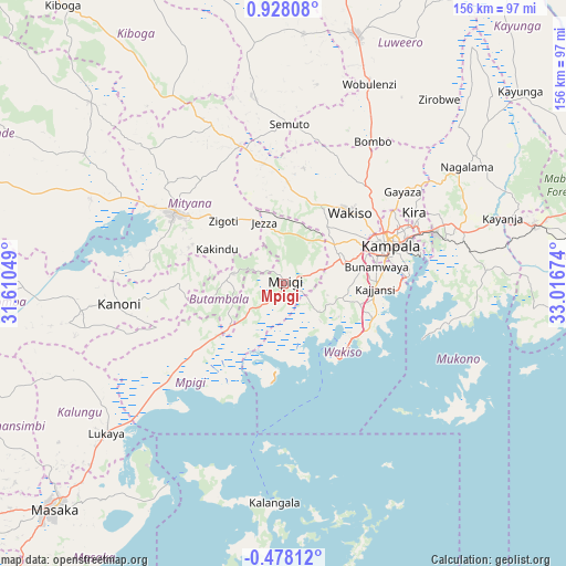
Mpigi GPS coordinates[2]
0° 13' 30" North, 32° 18' 48.996" East
| Map corner | latitude | longitude |
|---|---|---|
| Upper-left | 0.92808°, | 31.61049° |
| Center: | 0.225°, | 32.31361° |
| Lower-right: | -0.47812°, | 33.01674° |
| Map W x H: | 156.4×156.4 km | = 97.2×97.2mi |
| max Lat: | 3.66088° ⇑72.6% North |
| Mpigi: | 0.225° |
| min Lat: | ⇓27.4% South -1.28538° |
| min Long | Mpigi | max Long |
| 29.65° | 32.31361° | 34.95° |
| W 47.3%⇐ | ⇒52.7% E |
Elevation
Elevation of Mpigi is 1265 m = 4150 ft, and this is 6 m = 20 ft above average elevation for this country.
| Max E: |
4129 m = 13547 ft | 30.1% |
| Mpigi | 1265 m 4150 ft | |
| Avg. | 1259 m = 4131 ft | |
Min E: |
622 m = 2041 ft | 69.9% |
See also: Uganda elevation on elevation.city.
Geographical zone
Mpigi is located in North Torrid zone (between Equator and Tropic of Cancer). Distance of Equator is 25 km =15.5 mi to South.| Distance of | km | miles | from Mpigi |
|---|---|---|---|
| North Pole | 9982 | 6202.5 | to North |
| Arctic Circle | 7376.2 | 4583.4 | to North |
| Tropic Cancer | 2580.9 | 1603.7 | to North |
| Equator | 25 | 15.5 | to South |


Nearby cities:
15 places around Mpigi: (largest is in red/bold)
• Bweyogerere
41.6 km =25.8 mi,  69°
69°
• Entebbe
26.3 km =16.3 mi,  135°
135°
• Gombe
25.2 km =15.7 mi,  264°
264°
• Gombe
34.5 km =21.4 mi,  32°
32°
• Kajansi
24.6 km =15.3 mi,  92°
92°
• Kampala
31.5 km =19.6 mi, 71°
• Kampala Central Division
31.1 km =19.3 mi, 69°
• Kanoni
48.4 km =30.1 mi, 263°
• Kireka
39.7 km =24.7 mi, 69°
• Lweeza
30.2 km =18.8 mi, 93°
• Mityana
38.8 km =24.1 mi,  303°
303°
• Mukono
51.1 km =31.8 mi, 73°
• Nakaseke
59.1 km =36.7 mi,  7°
7°
• Namasuba
53 km =32.9 mi, 13°
• Wakiso
25.7 km =16 mi,  39°
39°
Sources, notices
• [Note1] Compared only with cities in Uganda existing in our database
• [Src1] Map data: © OpenStreetMap contributors (CC-BY-SA)
• [Src2] Other city data from geonames.org with taken over terms of usage.
• [Src3] Geographical zone / Annual Mean Temperature by Robert A. Rohde @ Wikipedia
