Kampala geodata
Kampala (Central Region) is a capital of a political entity; located in Uganda in Africa/Kampala (GMT+3) time zone. With population of 1,353,189 people, there are 0 cities with bigger population in this country. Compared to other cities in Uganda, 71.2% of cities are located further ↑North; 56.2% of cities are located further ←West and 60.3% of cities have lower elevation than Kampala. Note1
Administrative division(s):
- Level 1: Central Region
- Level 2: Kampala District
- Level 3: Kampala Capital City
- Level 4: Central Division


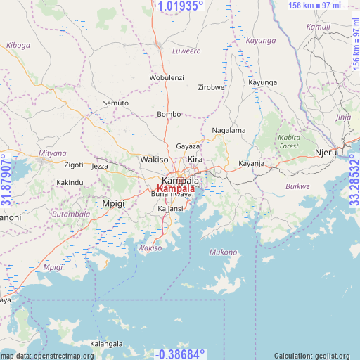
Kampala GPS coordinates[2]
0° 18' 58.608" North, 32° 34' 55.884" East
| Map corner | latitude | longitude |
|---|---|---|
| Upper-left | 1.01935°, | 31.87907° |
| Center: | 0.31628°, | 32.58219° |
| Lower-right: | -0.38684°, | 33.28532° |
| Map W x H: | 156.4×156.4 km | = 97.2×97.2mi |
| max Lat: | 3.66088° ⇑71.2% North |
| Kampala: | 0.31628° |
| min Lat: | ⇓28.8% South -1.28538° |
| min Long | Kampala | max Long |
| 29.65° | 32.58219° | 34.95° |
| W 56.2%⇐ | ⇒43.8% E |
Elevation
Elevation of Kampala is 1223 m = 4012 ft, and this is 36 m = 118 ft below average elevation for this country.
| Max E: |
4129 m = 13547 ft | 39.7% |
| Avg. | 1259 m = 4131 ft | |
| Kampala | 1223 m = 4012 ft | |
Min E: |
622 m = 2041 ft | 60.3% |
See also: Kampala elevation on elevation.city.
Geographical zone
Kampala is located in North Torrid zone (between Equator and Tropic of Cancer). Distance of Equator is 35.2 km =21.9 mi to South.| Distance of | km | miles | from Kampala |
|---|---|---|---|
| North Pole | 9971.9 | 6196.2 | to North |
| Arctic Circle | 7366 | 4577 | to North |
| Tropic Cancer | 2570.8 | 1597.4 | to North |
| Equator | 35.2 | 21.9 | to South |


Nearby cities:
15 places around Kampala: (largest is in red/bold)
• Buikwe
47.7 km =29.6 mi,  87°
87°
• Bweyogerere
10.1 km =6.3 mi,  62°
62°
• Entebbe
31.1 km =19.3 mi,  201°
201°
• Gombe
22.2 km =13.8 mi,  328°
328°
• Kajansi
12.4 km =7.7 mi,  205°
205°
• Kampala Central Division
1.3 km =0.8 mi,  318°
318°
• Kireka
8.2 km =5.1 mi,  65°
65°
• Lugazi
39.9 km =24.8 mi,  81°
81°
• Lweeza
11.8 km =7.3 mi,  178°
178°
• Mpigi
31.5 km =19.6 mi,  251°
251°
• Mukono
19.7 km =12.2 mi, 77°
• Nakaseke
53.1 km =33 mi,  335°
335°
• Namasuba
45.2 km =28.1 mi, 336°
• Wakiso
16.8 km =10.4 mi,  305°
305°
• Wobulenzi
46.5 km =28.9 mi,  350°
350°
Sources, notices
• [Note1] Compared only with cities in Uganda existing in our database
• [Src1] Map data: © OpenStreetMap contributors (CC-BY-SA)
• [Src2] Other city data from geonames.org with taken over terms of usage.
• [Src3] Geographical zone / Annual Mean Temperature by Robert A. Rohde @ Wikipedia
