Gombe geodata
Gombe (Central Region) is a seat of a second-order administrative division; located in Uganda in Africa/Kampala (GMT+3) time zone. In our database, there are 80 cities with bigger population. Compared to other cities in Uganda, 75.3% of cities are located further ↑North; 54.8% of cities are located further →East and 50.7% of cities have lower elevation than Gombe. Note1
Administrative division(s):
- Level 1: Central Region
- Level 2: Gomba District
- Level 3: Gomba County
- Level 4: Mpenja


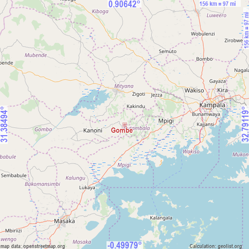
Gombe GPS coordinates[2]
0° 12' 11.988" North, 32° 5' 17.016" East
| Map corner | latitude | longitude |
|---|---|---|
| Upper-left | 0.90642°, | 31.38494° |
| Center: | 0.20333°, | 32.08806° |
| Lower-right: | -0.49979°, | 32.79119° |
| Map W x H: | 156.4×156.4 km | = 97.2×97.2mi |
| max Lat: | 3.66088° ⇑75.3% North |
| Gombe: | 0.20333° |
| min Lat: | ⇓24.7% South -1.28538° |
| min Long | Gombe | max Long |
| 29.65° | 32.08806° | 34.95° |
| W 45.2%⇐ | ⇒54.8% E |
Elevation
Elevation of Gombe is 1190 m = 3904 ft, and this is 69 m = 226 ft below average elevation for this country.
| Max E: |
4129 m = 13547 ft | 49.3% |
| Avg. | 1259 m = 4131 ft | |
| Gombe | 1190 m = 3904 ft | |
Min E: |
622 m = 2041 ft | 50.7% |
See also: Uganda elevation on elevation.city.
Geographical zone
Gombe is located in North Torrid zone (between Equator and Tropic of Cancer). Distance of Equator is 22.6 km =14 mi to South.| Distance of | km | miles | from Gombe |
|---|---|---|---|
| North Pole | 9984.5 | 6204.1 | to North |
| Arctic Circle | 7378.6 | 4584.8 | to North |
| Tropic Cancer | 2583.3 | 1605.2 | to North |
| Equator | 22.6 | 14 | to South |


Nearby cities:
15 places around Gombe: (largest is in red/bold)
• Bweyogerere
66.2 km =41.1 mi,  74°
74°
• Entebbe
46.5 km =28.9 mi,  110°
110°
• Gombe
53.7 km =33.4 mi,  54°
54°
• Kajansi
49.7 km =30.9 mi,  88°
88°
• Kalangala
59 km =36.7 mi,  165°
165°
• Kalungu
55.3 km =34.4 mi,  221°
221°
• Kampala
56.4 km =35 mi,  77°
77°
• Kampala Central Division
55.8 km =34.7 mi, 75°
• Kanoni
23.2 km =14.4 mi,  262°
262°
• Kireka
64.4 km =40 mi, 75°
• Lweeza
55.3 km =34.4 mi, 89°
• Mityana
24.9 km =15.5 mi,  343°
343°
• Mpigi
25.2 km =15.7 mi, 84°
• Namasuba
65.5 km =40.7 mi,  34°
34°
• Wakiso
47 km =29.2 mi,  61°
61°
Sources, notices
• [Note1] Compared only with cities in Uganda existing in our database
• [Src1] Map data: © OpenStreetMap contributors (CC-BY-SA)
• [Src2] Other city data from geonames.org with taken over terms of usage.
• [Src3] Geographical zone / Annual Mean Temperature by Robert A. Rohde @ Wikipedia
