Gombe geodata
Gombe (Central Region) is a seat of a fourth-order administrative division; located in Uganda in Africa/Kampala (GMT+3) time zone. In our database, there are 80 cities with bigger population. Compared to other cities in Uganda, 60.3% of cities are located further ↑North; 52.1% of cities are located further ←West and 54.1% of cities have higher elevation than Gombe. Note1
Administrative division(s):
- Level 1: Central Region
- Level 2: Wakiso District
- Level 3: Kyadondo
- Level 4: Gombe


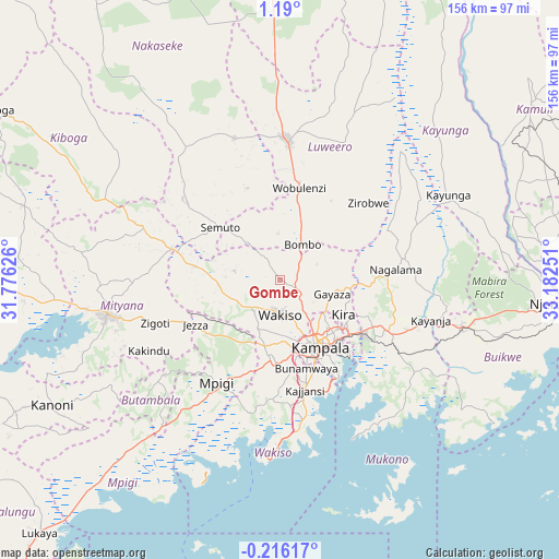
Gombe GPS coordinates[2]
0° 29' 13.02" North, 32° 28' 45.768" East
| Map corner | latitude | longitude |
|---|---|---|
| Upper-left | 1.19°, | 31.77626° |
| Center: | 0.48695°, | 32.47938° |
| Lower-right: | -0.21617°, | 33.18251° |
| Map W x H: | 156.4×156.4 km | = 97.2×97.2mi |
| max Lat: | 3.66088° ⇑60.3% North |
| Gombe: | 0.48695° |
| min Lat: | ⇓39.7% South -1.28538° |
| min Long | Gombe | max Long |
| 29.65° | 32.47938° | 34.95° |
| W 52.1%⇐ | ⇒47.9% E |
Elevation
Elevation of Gombe is 1172 m = 3845 ft, and this is 87 m = 285 ft below average elevation for this country.
| Max E: |
4129 m = 13547 ft | 54.1% |
| Avg. | 1259 m = 4131 ft | |
| Gombe | 1172 m = 3845 ft | |
Min E: |
622 m = 2041 ft | 45.9% |
See also: Uganda elevation on elevation.city.
Geographical zone
Gombe is located in North Torrid zone (between Equator and Tropic of Cancer). Distance of Equator is 54.1 km =33.6 mi to South.| Distance of | km | miles | from Gombe |
|---|---|---|---|
| North Pole | 9952.9 | 6184.4 | to North |
| Arctic Circle | 7347 | 4565.2 | to North |
| Tropic Cancer | 2551.8 | 1585.6 | to North |
| Equator | 54.1 | 33.6 | to South |


Nearby cities:
15 places around Gombe: (largest is in red/bold)
• Bweyogerere
25 km =15.5 mi,  125°
125°
• Entebbe
47.9 km =29.8 mi,  179°
179°
• Kajansi
30.8 km =19.1 mi,  168°
168°
• Kampala
22.2 km =13.8 mi,  148°
148°
• Kampala Central Division
20.9 km =13 mi, 149°
• Kayunga
51.4 km =31.9 mi,  62°
62°
• Kireka
24.4 km =15.2 mi, 129°
• Luwero
40.3 km =25 mi,  359°
359°
• Lweeza
33 km =20.5 mi,  159°
159°
• Mpigi
34.5 km =21.4 mi,  212°
212°
• Mukono
34.1 km =21.2 mi,  115°
115°
• Nakaseke
31.2 km =19.4 mi,  340°
340°
• Namasuba
23.4 km =14.5 mi, 344°
• Wakiso
9.4 km =5.8 mi,  193°
193°
• Wobulenzi
27.1 km =16.8 mi,  7°
7°
Sources, notices
• [Note1] Compared only with cities in Uganda existing in our database
• [Src1] Map data: © OpenStreetMap contributors (CC-BY-SA)
• [Src2] Other city data from geonames.org with taken over terms of usage.
• [Src3] Geographical zone / Annual Mean Temperature by Robert A. Rohde @ Wikipedia
