Busia geodata
Busia (Eastern Region) is a seat of a second-order administrative division; located in Uganda in Africa/Kampala (GMT+3) time zone. With population of 43,200 people, there are 17 cities with bigger population in this country. Compared to other cities in Uganda, 62.3% of cities are located further ↑North; 89% of cities are located further ←West and 58.9% of cities have lower elevation than Busia. Note1
Administrative division(s):
- Level 1: Eastern Region
- Level 2: Busia District
- Level 3: Samia-Bugwe
- Level 4: Eastern Division


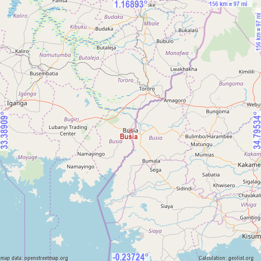
Busia GPS coordinates[2]
0° 27' 57.168" North, 34° 5' 31.956" East
| Map corner | latitude | longitude |
|---|---|---|
| Upper-left | 1.16893°, | 33.38909° |
| Center: | 0.46588°, | 34.09221° |
| Lower-right: | -0.23724°, | 34.79534° |
| Map W x H: | 156.4×156.4 km | = 97.2×97.2mi |
| max Lat: | 3.66088° ⇑62.3% North |
| Busia: | 0.46588° |
| min Lat: | ⇓37.7% South -1.28538° |
| min Long | Busia | max Long |
| 29.65° | 34.09221° | 34.95° |
| W 89%⇐ | ⇒11% E |
Elevation
Elevation of Busia is 1219 m = 3999 ft, and this is 40 m = 131 ft below average elevation for this country.
| Max E: |
4129 m = 13547 ft | 41.1% |
| Avg. | 1259 m = 4131 ft | |
| Busia | 1219 m = 3999 ft | |
Min E: |
622 m = 2041 ft | 58.9% |
See also: Busia elevation on elevation.city.
Geographical zone
Busia is located in North Torrid zone (between Equator and Tropic of Cancer). Distance of Equator is 51.8 km =32.2 mi to South.| Distance of | km | miles | from Busia |
|---|---|---|---|
| North Pole | 9955.3 | 6185.9 | to North |
| Arctic Circle | 7349.4 | 4566.7 | to North |
| Tropic Cancer | 2554.1 | 1587 | to North |
| Equator | 51.8 | 32.2 | to South |


Nearby cities:
15 places around Busia: (largest is in red/bold)
• Budaka
62.6 km =38.9 mi,  342°
342°
• Bududa
66.2 km =41.1 mi,  23°
23°
• Bugiri
40.7 km =25.3 mi,  286°
286°
• Bupoto
57.2 km =35.5 mi,  31°
31°
• Busembatia
62.6 km =38.9 mi,  303°
303°
• Butaleja
52 km =32.3 mi, 342°
• Iganga
71.1 km =44.2 mi,  282°
282°
• Kaliro
81.3 km =50.5 mi,  305°
305°
• Kibuku
72.1 km =44.8 mi,  332°
332°
• Manafwa
65 km =40.4 mi, 28°
• Mayuge
68 km =42.3 mi,  269°
269°
• Mbale
69.1 km =42.9 mi,  7°
7°
• Namayingo
34.1 km =21.2 mi,  222°
222°
• Namutumba
61.1 km =38 mi, 312°
• Tororo
27.1 km =16.8 mi, 21°
Sources, notices
• [Note1] Compared only with cities in Uganda existing in our database
• [Src1] Map data: © OpenStreetMap contributors (CC-BY-SA)
• [Src2] Other city data from geonames.org with taken over terms of usage.
• [Src3] Geographical zone / Annual Mean Temperature by Robert A. Rohde @ Wikipedia
