Mbale geodata
Mbale (Eastern Region) is a seat of a second-order administrative division; located in Uganda in Africa/Kampala (GMT+3) time zone. With population of 76,493 people, there are 6 cities with bigger population in this country. Compared to other cities in Uganda, 61.6% of cities are located further ↓South; 91.1% of cities are located further ←West and 67.1% of cities have higher elevation than Mbale. Note1
Administrative division(s):
- Level 1: Eastern Region
- Level 2: Mbale District
- Level 3: Mbale Municipality
- Level 4: Northern Division


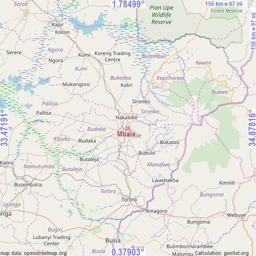
Mbale GPS coordinates[2]
1° 4' 55.524" North, 34° 10' 30.108" East
| Map corner | latitude | longitude |
|---|---|---|
| Upper-left | 1.78499°, | 33.47191° |
| Center: | 1.08209°, | 34.17503° |
| Lower-right: | 0.37903°, | 34.87816° |
| Map W x H: | 156.3×156.3 km | = 97.1×97.1mi |
| max Lat: | 3.66088° ⇑38.4% North |
| Mbale: | 1.08209° |
| min Lat: | ⇓61.6% South -1.28538° |
| min Long | Mbale | max Long |
| 29.65° | 34.17503° | 34.95° |
| W 91.1%⇐ | ⇒8.9% E |
Elevation
Elevation of Mbale is 1125 m = 3691 ft, and this is 134 m = 440 ft below average elevation for this country.
| Max E: |
4129 m = 13547 ft | 67.1% |
| Avg. | 1259 m = 4131 ft | |
| Mbale | 1125 m = 3691 ft | |
Min E: |
622 m = 2041 ft | 32.9% |
See also: Mbale elevation on elevation.city.
Geographical zone
Mbale is located in North Torrid zone (between Equator and Tropic of Cancer). Distance of Equator is 120.3 km =74.8 mi to South.| Distance of | km | miles | from Mbale |
|---|---|---|---|
| North Pole | 9886.7 | 6143.3 | to North |
| Arctic Circle | 7280.9 | 4524.1 | to North |
| Tropic Cancer | 2485.6 | 1544.5 | to North |
| Equator | 120.3 | 74.8 | to South |


Nearby cities:
15 places around Mbale: (largest is in red/bold)
• Binyin
54.5 km =33.9 mi,  46°
46°
• Budaka
29.1 km =18.1 mi,  252°
252°
• Bududa
19.1 km =11.9 mi,  114°
114°
• Bukedea
29.6 km =18.4 mi,  332°
332°
• Bulambuli
25 km =15.5 mi,  67°
67°
• Bupoto
28.2 km =17.5 mi,  133°
133°
• Butaleja
31.3 km =19.4 mi,  232°
232°
• Butebo
30.7 km =19.1 mi,  293°
293°
• Kapchorwa
46.8 km =29.1 mi,  40°
40°
• Kibuku
42.2 km =26.2 mi,  264°
264°
• Kumi
49.8 km =30.9 mi, 327°
• Manafwa
25 km =15.5 mi,  117°
117°
• Pallisa
52.2 km =32.4 mi,  277°
277°
• Sironko
18.5 km =11.5 mi,  25°
25°
• Tororo
43.3 km =26.9 mi,  179°
179°
Sources, notices
• [Note1] Compared only with cities in Uganda existing in our database
• [Src1] Map data: © OpenStreetMap contributors (CC-BY-SA)
• [Src2] Other city data from geonames.org with taken over terms of usage.
• [Src3] Geographical zone / Annual Mean Temperature by Robert A. Rohde @ Wikipedia
