Bugiri geodata
Bugiri (Eastern Region) is a seat of a second-order administrative division; located in Uganda in Africa/Kampala (GMT+3) time zone. With population of 22,500 people, there are 34 cities with bigger population in this country. Compared to other cities in Uganda, 58.2% of cities are located further ↑North; 82.2% of cities are located further ←West and 62.3% of cities have higher elevation than Bugiri. Note1
Administrative division(s):
- Level 1: Eastern Region
- Level 2: Namayingo District
- Level 3: Bukooli
- Level 4: Bugiri Town Council


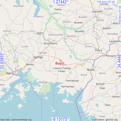
Bugiri GPS coordinates[2]
0° 34' 17.004" North, 33° 44' 30.012" East
| Map corner | latitude | longitude |
|---|---|---|
| Upper-left | 1.27442°, | 33.03855° |
| Center: | 0.57139°, | 33.74167° |
| Lower-right: | -0.13173°, | 34.4448° |
| Map W x H: | 156.3×156.4 km | = 97.1×97.2mi |
| max Lat: | 3.66088° ⇑58.2% North |
| Bugiri: | 0.57139° |
| min Lat: | ⇓41.8% South -1.28538° |
| min Long | Bugiri | max Long |
| 29.65° | 33.74167° | 34.95° |
| W 82.2%⇐ | ⇒17.8% E |
Elevation
Elevation of Bugiri is 1138 m = 3734 ft, and this is 121 m = 397 ft below average elevation for this country.
| Max E: |
4129 m = 13547 ft | 62.3% |
| Avg. | 1259 m = 4131 ft | |
| Bugiri | 1138 m = 3734 ft | |
Min E: |
622 m = 2041 ft | 37.7% |
See also: Uganda elevation on elevation.city.
Geographical zone
Bugiri is located in North Torrid zone (between Equator and Tropic of Cancer). Distance of Equator is 63.5 km =39.5 mi to South.| Distance of | km | miles | from Bugiri |
|---|---|---|---|
| North Pole | 9943.5 | 6178.6 | to North |
| Arctic Circle | 7337.6 | 4559.4 | to North |
| Tropic Cancer | 2542.4 | 1579.8 | to North |
| Equator | 63.5 | 39.5 | to South |


Nearby cities:
15 places around Bugiri: (largest is in red/bold)
• Budaka
52.3 km =32.5 mi,  23°
23°
• Bugembe
56.6 km =35.2 mi,  259°
259°
• Busembatia
26.4 km =16.4 mi,  330°
330°
• Busia
40.7 km =25.3 mi,  106°
106°
• Butaleja
44.5 km =27.7 mi,  31°
31°
• Iganga
30.6 km =19 mi,  277°
277°
• Jinja
61.7 km =38.3 mi, 256°
• Kaliro
44.9 km =27.9 mi,  323°
323°
• Kibuku
52.8 km =32.8 mi,  6°
6°
• Luuka Town
51.1 km =31.8 mi,  286°
286°
• Mayuge
31.6 km =19.6 mi,  246°
246°
• Namayingo
40.2 km =25 mi,  156°
156°
• Namutumba
30.1 km =18.7 mi,  348°
348°
• Pallisa
63.9 km =39.7 mi,  356°
356°
• Tororo
50.7 km =31.5 mi,  74°
74°
Sources, notices
• [Note1] Compared only with cities in Uganda existing in our database
• [Src1] Map data: © OpenStreetMap contributors (CC-BY-SA)
• [Src2] Other city data from geonames.org with taken over terms of usage.
• [Src3] Geographical zone / Annual Mean Temperature by Robert A. Rohde @ Wikipedia
