Bududa geodata
Bududa (Eastern Region) is a seat of a second-order administrative division; located in Uganda in Africa/Kampala (GMT+3) time zone. In our database, there are 80 cities with bigger population. Compared to other cities in Uganda, 59.6% of cities are located further ↓South; 93.8% of cities are located further ←West and 73.3% of cities have lower elevation than Bududa. Note1
Administrative division(s):
- Level 1: Eastern Region
- Level 2: Bududa District
- Level 3: Manjiya
- Level 4: Bududa


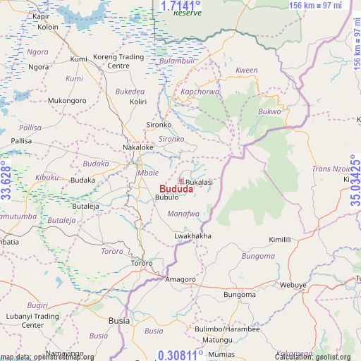
Bududa GPS coordinates[2]
1° 0' 40.248" North, 34° 19' 52.032" East
| Map corner | latitude | longitude |
|---|---|---|
| Upper-left | 1.7141°, | 33.628° |
| Center: | 1.01118°, | 34.33112° |
| Lower-right: | 0.30811°, | 35.03425° |
| Map W x H: | 156.3×156.3 km | = 97.1×97.1mi |
| max Lat: | 3.66088° ⇑40.4% North |
| Bududa: | 1.01118° |
| min Lat: | ⇓59.6% South -1.28538° |
| min Long | Bududa | max Long |
| 29.65° | 34.33112° | 34.95° |
| W 93.8%⇐ | ⇒6.2% E |
Elevation
Elevation of Bududa is 1303 m = 4275 ft, and this is 44 m = 144 ft above average elevation for this country.
| Max E: |
4129 m = 13547 ft | 26.7% |
| Bududa | 1303 m 4275 ft | |
| Avg. | 1259 m = 4131 ft | |
Min E: |
622 m = 2041 ft | 73.3% |
See also: Uganda elevation on elevation.city.
Geographical zone
Bududa is located in North Torrid zone (between Equator and Tropic of Cancer). Distance of Equator is 112.4 km =69.8 mi to South.| Distance of | km | miles | from Bududa |
|---|---|---|---|
| North Pole | 9894.6 | 6148.2 | to North |
| Arctic Circle | 7288.7 | 4529 | to North |
| Tropic Cancer | 2493.5 | 1549.4 | to North |
| Equator | 112.4 | 69.8 | to South |


Nearby cities:
15 places around Bududa: (largest is in red/bold)
• Binyin
50.4 km =31.3 mi,  26°
26°
• Budaka
45.1 km =28 mi,  268°
268°
• Bukedea
46.1 km =28.6 mi,  317°
317°
• Bukwa
54.5 km =33.9 mi,  59°
59°
• Bulambuli
18.2 km =11.3 mi,  18°
18°
• Bupoto
12.1 km =7.5 mi,  165°
165°
• Busia
66.2 km =41.1 mi,  203°
203°
• Butaleja
43.7 km =27.2 mi,  255°
255°
• Butebo
49.8 km =30.9 mi,  294°
294°
• Kapchorwa
45.3 km =28.1 mi, 17°
• Kibuku
59.4 km =36.9 mi, 273°
• Manafwa
6 km =3.7 mi,  127°
127°
• Mbale
19.1 km =11.9 mi, 294°
• Sironko
26.2 km =16.3 mi,  339°
339°
• Tororo
39.1 km =24.3 mi,  205°
205°
Sources, notices
• [Note1] Compared only with cities in Uganda existing in our database
• [Src1] Map data: © OpenStreetMap contributors (CC-BY-SA)
• [Src2] Other city data from geonames.org with taken over terms of usage.
• [Src3] Geographical zone / Annual Mean Temperature by Robert A. Rohde @ Wikipedia
