Busembatia geodata
Busembatia (Eastern Region) is a populated place; located in Uganda in Africa/Kampala (GMT+3) time zone. With population of 15,889 people, there are 45 cities with bigger population in this country. Compared to other cities in Uganda, 50% of cities are located further ↓South; 78.8% of cities are located further ←West and 70.5% of cities have higher elevation than Busembatia. Note1
Administrative division(s):
- Level 1: Eastern Region
- Level 2: Iganga District
- Level 3: Bugweri County
- Level 4: Namalemba


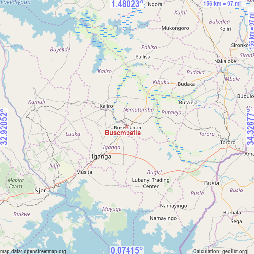
Busembatia GPS coordinates[2]
0° 46' 38.1" North, 33° 37' 25.104" East
| Map corner | latitude | longitude |
|---|---|---|
| Upper-left | 1.48023°, | 32.92052° |
| Center: | 0.77725°, | 33.62364° |
| Lower-right: | 0.07415°, | 34.32677° |
| Map W x H: | 156.3×156.3 km | = 97.1×97.1mi |
| max Lat: | 3.66088° ⇑50% North |
| Busembatia: | 0.77725° |
| min Lat: | ⇓50% South -1.28538° |
| min Long | Busembatia | max Long |
| 29.65° | 33.62364° | 34.95° |
| W 78.8%⇐ | ⇒21.2% E |
Elevation
Elevation of Busembatia is 1123 m = 3684 ft, and this is 136 m = 446 ft below average elevation for this country.
| Max E: |
4129 m = 13547 ft | 70.5% |
| Avg. | 1259 m = 4131 ft | |
| Busembatia | 1123 m = 3684 ft | |
Min E: |
622 m = 2041 ft | 29.5% |
See also: Uganda elevation on elevation.city.
Geographical zone
Busembatia is located in North Torrid zone (between Equator and Tropic of Cancer). Distance of Equator is 86.4 km =53.7 mi to South.| Distance of | km | miles | from Busembatia |
|---|---|---|---|
| North Pole | 9920.6 | 6164.4 | to North |
| Arctic Circle | 7314.8 | 4545.2 | to North |
| Tropic Cancer | 2519.5 | 1565.5 | to North |
| Equator | 86.4 | 53.7 | to South |


Nearby cities:
15 places around Busembatia: (largest is in red/bold)
• Budaka
42 km =26.1 mi,  53°
53°
• Bugembe
53.8 km =33.4 mi,  232°
232°
• Bugiri
26.4 km =16.4 mi,  150°
150°
• Butaleja
39.4 km =24.5 mi,  67°
67°
• Butebo
57 km =35.4 mi,  35°
35°
• Buwenge
52.2 km =32.4 mi,  254°
254°
• Iganga
25.4 km =15.8 mi,  222°
222°
• Jinja
60 km =37.3 mi, 231°
• Kaliro
19 km =11.8 mi,  313°
313°
• Kamuli
59.1 km =36.7 mi,  288°
288°
• Kibuku
35.3 km =21.9 mi,  33°
33°
• Luuka Town
37 km =23 mi,  256°
256°
• Mayuge
38.7 km =24 mi,  204°
204°
• Namutumba
9.5 km =5.9 mi, 46°
• Pallisa
42 km =26.1 mi,  13°
13°
Sources, notices
• [Note1] Compared only with cities in Uganda existing in our database
• [Src1] Map data: © OpenStreetMap contributors (CC-BY-SA)
• [Src2] Other city data from geonames.org with taken over terms of usage.
• [Src3] Geographical zone / Annual Mean Temperature by Robert A. Rohde @ Wikipedia
