Kapchorwa geodata
Kapchorwa (Eastern Region) is a seat of a second-order administrative division; located in Uganda in Africa/Kampala (GMT+3) time zone. With population of 11,300 people, there are 61 cities with bigger population in this country. Compared to other cities in Uganda, 68.5% of cities are located further ↓South; 96.6% of cities are located further ←West and 96.6% of cities have lower elevation than Kapchorwa. Note1
Administrative division(s):
- Level 1: Eastern Region
- Level 2: Kapchorwa District
- Level 3: Tingey County
- Level 4: Kapchorwa Town Council


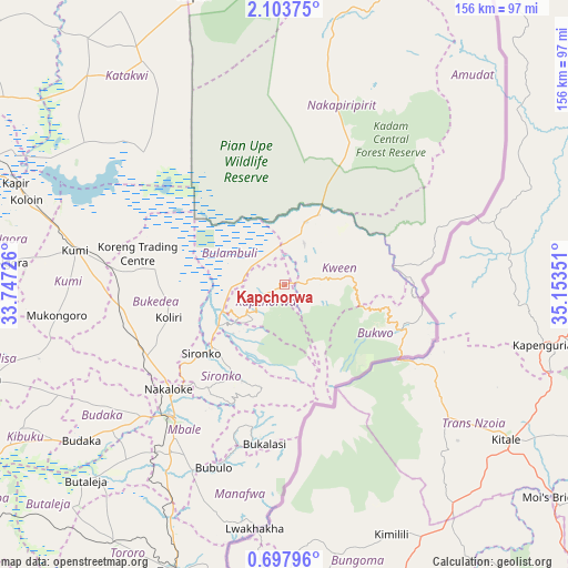
Kapchorwa GPS coordinates[2]
1° 24' 3.456" North, 34° 27' 1.368" East
| Map corner | latitude | longitude |
|---|---|---|
| Upper-left | 2.10375°, | 33.74726° |
| Center: | 1.40096°, | 34.45038° |
| Lower-right: | 0.69796°, | 35.15351° |
| Map W x H: | 156.3×156.3 km | = 97.1×97.1mi |
| max Lat: | 3.66088° ⇑31.5% North |
| Kapchorwa: | 1.40096° |
| min Lat: | ⇓68.5% South -1.28538° |
| min Long | Kapchorwa | max Long |
| 29.65° | 34.45038° | 34.95° |
| W 96.6%⇐ | ⇒3.4% E |
Elevation
Elevation of Kapchorwa is 1915 m = 6283 ft, and this is 656 m = 2152 ft above average elevation for this country.
| Max E: |
4129 m = 13547 ft | 3.4% |
| Kapchorwa | 1915 m 6283 ft | |
| Avg. | 1259 m = 4131 ft | |
Min E: |
622 m = 2041 ft | 96.6% |
See also: Uganda elevation on elevation.city.
Geographical zone
Kapchorwa is located in North Torrid zone (between Equator and Tropic of Cancer). Distance of Equator is 155.8 km =96.8 mi to South.| Distance of | km | miles | from Kapchorwa |
|---|---|---|---|
| North Pole | 9851.3 | 6121.3 | to North |
| Arctic Circle | 7245.4 | 4502.1 | to North |
| Tropic Cancer | 2450.1 | 1522.4 | to North |
| Equator | 155.8 | 96.8 | to South |


Nearby cities:
15 places around Kapchorwa: (largest is in red/bold)
• Binyin
9.4 km =5.8 mi,  79°
79°
• Budaka
73.2 km =45.5 mi,  232°
232°
• Bududa
45.3 km =28.1 mi,  197°
197°
• Bukedea
45.4 km =28.2 mi,  258°
258°
• Bukwa
37.2 km =23.1 mi,  115°
115°
• Bulambuli
27.1 km =16.8 mi, 195°
• Bupoto
56 km =34.8 mi,  190°
190°
• Butebo
63.1 km =39.2 mi,  248°
248°
• Katakwi
76.6 km =47.6 mi,  315°
315°
• Kumi
57.5 km =35.7 mi,  276°
276°
• Manafwa
47.7 km =29.6 mi, 190°
• Mbale
46.8 km =29.1 mi,  220°
220°
• Nakapiripirit
68.2 km =42.4 mi,  32°
32°
• Ngora
74.9 km =46.5 mi,  272°
272°
• Sironko
29.4 km =18.3 mi, 230°
Sources, notices
• [Note1] Compared only with cities in Uganda existing in our database
• [Src1] Map data: © OpenStreetMap contributors (CC-BY-SA)
• [Src2] Other city data from geonames.org with taken over terms of usage.
• [Src3] Geographical zone / Annual Mean Temperature by Robert A. Rohde @ Wikipedia
