Evergreen geodata
Evergreen (Alabama) is a seat of a second-order administrative division; located in United States in America/Chicago (GMT-5) time zone. With population of 3,774 people, there are 8495 cities with bigger population in this country. Compared to other cities in United States, 89.8% of cities are located further ↑North; 50.4% of cities are located further ←West and 71.8% of cities have higher elevation than Evergreen. Note1


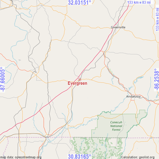
Evergreen GPS coordinates[2]
31° 26' 0.6" North, 86° 57' 24.912" West
| Map corner | latitude | longitude |
|---|---|---|
| Upper-left | 32.03151°, | -87.66005° |
| Center: | 31.4335°, | -86.95692° |
| Lower-right: | 30.83165°, | -86.2538° |
| Map W x H: | 133.4×133.4 km | = 82.9×82.9mi |
| max Lat: | 71.29058° ⇑89.8% North |
| Evergreen: | 31.4335° |
| min Lat: | ⇓10.2% South 19.06759° |
| min Long | Evergreen | max Long |
| -171.73463° | -86.95692° | -66.98998° |
| W 50.4%⇐ | ⇒49.6% E |
Elevation
Elevation of Evergreen is 90 m = 295 ft, and this is 204.8 m = 672 ft below average elevation for this country.
| Max E: |
3189 m = 10463 ft | 71.8% |
| Avg. | 294.8 m = 967 ft | |
| Evergreen | 90 m = 295 ft | |
Min E: |
-60 m = -197 ft | 28.2% |
See also: United States elevation on elevation.city.
Geographical zone
Evergreen is located in North temperate zone (between Tropic of Cancer and the Arctic Circle). Distance of this Northern Tropic circle is 889.2 km =552.5 mi to South.| Distance of | km | miles | from Evergreen |
|---|---|---|---|
| North Pole | 6512 | 4046.4 | to North |
| Arctic Circle | 3906.1 | 2427.1 | to North |
| Tropic Cancer | 889.2 | 552.5 | to South |
| Equator | 3495.1 | 2171.8 | to South |


Nearby cities:
15 places around Evergreen: (largest is in red/bold)
• Andalusia
47.2 km =29.3 mi,  107°
107°
• Babbie
62.3 km =38.7 mi, 105°
• Brewton
38.1 km =23.7 mi,  196°
196°
• Castleberry
16.2 km =10.1 mi, 202°
• Century
58.9 km =36.6 mi,  209°
209°
• East Brewton
39.1 km =24.3 mi,  194°
194°
• Excel
36.5 km =22.7 mi,  269°
269°
• Flomaton
56.2 km =34.9 mi, 210°
• Frisco City
42.2 km =26.2 mi, 270°
• Georgiana
30.5 km =19 mi,  41°
41°
• Greenville
54.5 km =33.9 mi, 36°
• Jay
56.5 km =35.1 mi, 199°
• McKenzie
25.9 km =16.1 mi,  62°
62°
• Monroeville
36.4 km =22.6 mi,  286°
286°
• River Falls
40.5 km =25.2 mi,  102°
102°
Sources, notices
• [Note1] Compared only with cities in United States existing in our database
• [Src1] Map data: © OpenStreetMap contributors (CC-BY-SA)
• [Src2] Other city data from geonames.org with taken over terms of usage.
• [Src3] Geographical zone / Annual Mean Temperature by Robert A. Rohde @ Wikipedia
