Andalusia geodata
Andalusia (Alabama) is a seat of a second-order administrative division; located in United States in America/Chicago (GMT-5) time zone. With population of 9,063 people, there are 4774 cities with bigger population in this country. Compared to other cities in United States, 90.1% of cities are located further ↑North; 51.6% of cities are located further ←West and 68.5% of cities have higher elevation than Andalusia. Note1


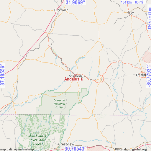
Andalusia GPS coordinates[2]
31° 18' 29.088" North, 86° 28' 56.748" West
| Map corner | latitude | longitude |
|---|---|---|
| Upper-left | 31.9069°, | -87.18556° |
| Center: | 31.30808°, | -86.48243° |
| Lower-right: | 30.70543°, | -85.77931° |
| Map W x H: | 133.6×133.6 km | = 83×83mi |
| max Lat: | 71.29058° ⇑90.1% North |
| Andalusia: | 31.30808° |
| min Lat: | ⇓9.9% South 19.06759° |
| min Long | Andalusia | max Long |
| -171.73463° | -86.48243° | -66.98998° |
| W 51.6%⇐ | ⇒48.4% E |
Elevation
Elevation of Andalusia is 110 m = 361 ft, and this is 184.8 m = 606 ft below average elevation for this country.
| Max E: |
3189 m = 10463 ft | 68.5% |
| Avg. | 294.8 m = 967 ft | |
| Andalusia | 110 m = 361 ft | |
Min E: |
-60 m = -197 ft | 31.5% |
See also: United States elevation on elevation.city.
Geographical zone
Andalusia is located in North temperate zone (between Tropic of Cancer and the Arctic Circle). Distance of this Northern Tropic circle is 875.2 km =543.8 mi to South.| Distance of | km | miles | from Andalusia |
|---|---|---|---|
| North Pole | 6525.9 | 4055 | to North |
| Arctic Circle | 3920 | 2435.8 | to North |
| Tropic Cancer | 875.2 | 543.8 | to South |
| Equator | 3481.1 | 2163.1 | to South |


Nearby cities:
15 places around Andalusia: (largest is in red/bold)
• Babbie
15.2 km =9.4 mi,  101°
101°
• Brantley
37.2 km =23.1 mi,  35°
35°
• Elba
41.1 km =25.5 mi,  73°
73°
• Evergreen
47.2 km =29.3 mi,  287°
287°
• Florala
36.7 km =22.8 mi,  156°
156°
• Georgiana
44.1 km =27.4 mi,  326°
326°
• Kinston
31.3 km =19.4 mi,  109°
109°
• Laurel Hill
38.1 km =23.7 mi,  176°
176°
• Lockhart
35.4 km =22 mi, 159°
• Luverne
49.9 km =31 mi,  24°
24°
• McKenzie
34.1 km =21.2 mi,  319°
319°
• Opp
21.7 km =13.5 mi, 97°
• Paxton
39.9 km =24.8 mi, 155°
• River Falls
7.5 km =4.7 mi,  312°
312°
• Samson
46.8 km =29.1 mi,  117°
117°
Sources, notices
• [Note1] Compared only with cities in United States existing in our database
• [Src1] Map data: © OpenStreetMap contributors (CC-BY-SA)
• [Src2] Other city data from geonames.org with taken over terms of usage.
• [Src3] Geographical zone / Annual Mean Temperature by Robert A. Rohde @ Wikipedia
