Lyerly geodata
Lyerly (Georgia) is a populated place; located in United States in America/New_York (GMT-4) time zone. With population of 529 people, there are 20514 cities with bigger population in this country. Compared to other cities in United States, 78.1% of cities are located further ↑North; 54.8% of cities are located further ←West and 50.5% of cities have higher elevation than Lyerly. Note1


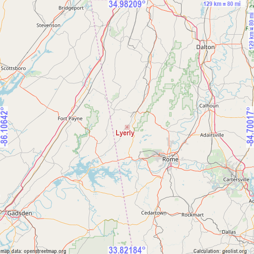
Lyerly GPS coordinates[2]
34° 24' 14.328" North, 85° 24' 11.844" West
| Map corner | latitude | longitude |
|---|---|---|
| Upper-left | 34.98209°, | -86.10642° |
| Center: | 34.40398°, | -85.40329° |
| Lower-right: | 33.82184°, | -84.70017° |
| Map W x H: | 129×129 km | = 80.2×80.2mi |
| max Lat: | 71.29058° ⇑78.1% North |
| Lyerly: | 34.40398° |
| min Lat: | ⇓21.9% South 19.06759° |
| min Long | Lyerly | max Long |
| -171.73463° | -85.40329° | -66.98998° |
| W 54.8%⇐ | ⇒45.2% E |
Elevation
Elevation of Lyerly is 196 m = 643 ft, and this is 98.8 m = 324 ft below average elevation for this country.
| Max E: |
3189 m = 10463 ft | 50.5% |
| Avg. | 294.8 m = 967 ft | |
| Lyerly | 196 m = 643 ft | |
Min E: |
-60 m = -197 ft | 49.5% |
See also: United States elevation on elevation.city.
Geographical zone
Lyerly is located in North temperate zone (between Tropic of Cancer and the Arctic Circle). Distance of this Northern Tropic circle is 1219.4 km =757.7 mi to South.| Distance of | km | miles | from Lyerly |
|---|---|---|---|
| North Pole | 6181.7 | 3841.1 | to North |
| Arctic Circle | 3575.8 | 2221.9 | to North |
| Tropic Cancer | 1219.4 | 757.7 | to South |
| Equator | 3825.4 | 2377 | to South |


Nearby cities:
15 places around Lyerly: (largest is in red/bold)
• Cave Spring
33.5 km =20.8 mi,  169°
169°
• Cedar Bluff
27.8 km =17.3 mi,  222°
222°
• Centre
37.8 km =23.5 mi, 222°
• Fort Payne
29.4 km =18.3 mi,  278°
278°
• LaFayette
35.2 km =21.9 mi,  18°
18°
• Leesburg
41.3 km =25.7 mi,  232°
232°
• Lindale
32 km =19.9 mi,  138°
138°
• Mount Vernon
37.4 km =23.2 mi,  250°
250°
• Rome
27.3 km =17 mi,  126°
126°
• Sand Rock
38 km =23.6 mi,  241°
241°
• Shannon
31.4 km =19.5 mi,  103°
103°
• Summerville
9.9 km =6.2 mi,  30°
30°
• Sylvania
41.4 km =25.7 mi,  295°
295°
• Trion
17.7 km =11 mi, 28°
• Valley Head
26.7 km =16.6 mi,  313°
313°
Sources, notices
• [Note1] Compared only with cities in United States existing in our database
• [Src1] Map data: © OpenStreetMap contributors (CC-BY-SA)
• [Src2] Other city data from geonames.org with taken over terms of usage.
• [Src3] Geographical zone / Annual Mean Temperature by Robert A. Rohde @ Wikipedia
