Vincent geodata
Vincent (Alabama) is a populated place; located in United States in America/Chicago (GMT-5) time zone. With population of 2,120 people, there are 11553 cities with bigger population in this country. Compared to other cities in United States, 83.7% of cities are located further ↑North; 51.8% of cities are located further ←West and 62.7% of cities have higher elevation than Vincent. Note1


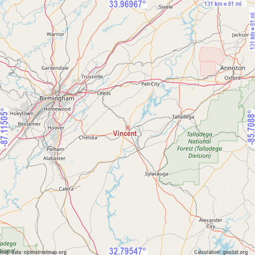
Vincent GPS coordinates[2]
33° 23' 4.38" North, 86° 24' 42.912" West
| Map corner | latitude | longitude |
|---|---|---|
| Upper-left | 33.96967°, | -87.11505° |
| Center: | 33.38455°, | -86.41192° |
| Lower-right: | 32.79547°, | -85.7088° |
| Map W x H: | 130.6×130.6 km | = 81.2×81.2mi |
| max Lat: | 71.29058° ⇑83.7% North |
| Vincent: | 33.38455° |
| min Lat: | ⇓16.3% South 19.06759° |
| min Long | Vincent | max Long |
| -171.73463° | -86.41192° | -66.98998° |
| W 51.8%⇐ | ⇒48.2% E |
Elevation
Elevation of Vincent is 140 m = 459 ft, and this is 154.8 m = 508 ft below average elevation for this country.
| Max E: |
3189 m = 10463 ft | 62.7% |
| Avg. | 294.8 m = 967 ft | |
| Vincent | 140 m = 459 ft | |
Min E: |
-60 m = -197 ft | 37.3% |
See also: United States elevation on elevation.city.
Geographical zone
Vincent is located in North temperate zone (between Tropic of Cancer and the Arctic Circle). Distance of this Northern Tropic circle is 1106.1 km =687.3 mi to South.| Distance of | km | miles | from Vincent |
|---|---|---|---|
| North Pole | 6295 | 3911.5 | to North |
| Arctic Circle | 3689.2 | 2292.4 | to North |
| Tropic Cancer | 1106.1 | 687.3 | to South |
| Equator | 3712 | 2306.5 | to South |


Nearby cities:
15 places around Vincent: (largest is in red/bold)
• Brook Highland
25 km =15.5 mi,  283°
283°
• Chelsea
20.9 km =13 mi,  256°
256°
• Childersburg
13 km =8.1 mi,  155°
155°
• Dunnavant
17.2 km =10.7 mi,  314°
314°
• Harpersville
5.1 km =3.2 mi,  208°
208°
• Highland Lakes
22.3 km =13.9 mi,  273°
273°
• Leeds
22 km =13.7 mi,  325°
325°
• Moody
24.1 km =15 mi,  342°
342°
• Oak Grove
23.8 km =14.8 mi,  153°
153°
• Pell City
25.3 km =15.7 mi,  27°
27°
• Shoal Creek
19.2 km =11.9 mi,  285°
285°
• Sterrett
9.5 km =5.9 mi,  318°
318°
• Vandiver
13.4 km =8.3 mi, 315°
• Westover
12.1 km =7.5 mi,  251°
251°
• Wilsonville
18 km =11.2 mi,  201°
201°
Sources, notices
• [Note1] Compared only with cities in United States existing in our database
• [Src1] Map data: © OpenStreetMap contributors (CC-BY-SA)
• [Src2] Other city data from geonames.org with taken over terms of usage.
• [Src3] Geographical zone / Annual Mean Temperature by Robert A. Rohde @ Wikipedia
