Oak Grove geodata
Oak Grove (Alabama) is a populated place; located in United States in America/Chicago (GMT-5) time zone. With population of 517 people, there are 20672 cities with bigger population in this country. Compared to other cities in United States, 84.4% of cities are located further ↑North; 52.1% of cities are located further ←West and 56.2% of cities have higher elevation than Oak Grove. Note1


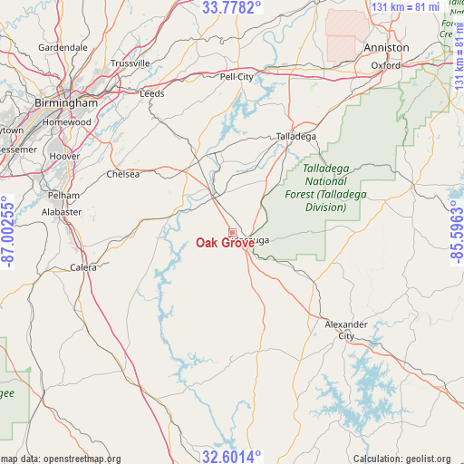
Oak Grove GPS coordinates[2]
33° 11' 30.408" North, 86° 17' 57.912" West
| Map corner | latitude | longitude |
|---|---|---|
| Upper-left | 33.7782°, | -87.00255° |
| Center: | 33.19178°, | -86.29942° |
| Lower-right: | 32.6014°, | -85.5963° |
| Map W x H: | 130.8×130.8 km | = 81.3×81.3mi |
| max Lat: | 71.29058° ⇑84.4% North |
| Oak Grove: | 33.19178° |
| min Lat: | ⇓15.6% South 19.06759° |
| min Long | Oak Grove | max Long |
| -171.73463° | -86.29942° | -66.98998° |
| W 52.1%⇐ | ⇒47.9% E |
Elevation
Elevation of Oak Grove is 175 m = 574 ft, and this is 119.8 m = 393 ft below average elevation for this country.
| Max E: |
3189 m = 10463 ft | 56.2% |
| Avg. | 294.8 m = 967 ft | |
| Oak Grove | 175 m = 574 ft | |
Min E: |
-60 m = -197 ft | 43.8% |
See also: United States elevation on elevation.city.
Geographical zone
Oak Grove is located in North temperate zone (between Tropic of Cancer and the Arctic Circle). Distance of this Northern Tropic circle is 1084.7 km =674 mi to South.| Distance of | km | miles | from Oak Grove |
|---|---|---|---|
| North Pole | 6316.5 | 3924.9 | to North |
| Arctic Circle | 3710.6 | 2305.7 | to North |
| Tropic Cancer | 1084.7 | 674 | to South |
| Equator | 3690.6 | 2293.2 | to South |


Nearby cities:
15 places around Oak Grove: (largest is in red/bold)
• Childersburg
10.9 km =6.8 mi,  331°
331°
• Columbiana
28.7 km =17.8 mi,  266°
266°
• Fayetteville
11.2 km =7 mi,  242°
242°
• Goodwater
26.9 km =16.7 mi,  121°
121°
• Harpersville
21.3 km =13.2 mi,  322°
322°
• Hollins
16.6 km =10.3 mi, 119°
• Mignon
3.7 km =2.3 mi,  104°
104°
• Shelby
28 km =17.4 mi,  251°
251°
• Sterrett
33.1 km =20.6 mi, 329°
• Stewartville
13.5 km =8.4 mi,  157°
157°
• Sylacauga
4.9 km =3 mi,  114°
114°
• Talladega
32.6 km =20.3 mi,  33°
33°
• Vincent
23.8 km =14.8 mi, 333°
• Westover
28.1 km =17.5 mi,  308°
308°
• Wilsonville
17.8 km =11.1 mi,  285°
285°
Sources, notices
• [Note1] Compared only with cities in United States existing in our database
• [Src1] Map data: © OpenStreetMap contributors (CC-BY-SA)
• [Src2] Other city data from geonames.org with taken over terms of usage.
• [Src3] Geographical zone / Annual Mean Temperature by Robert A. Rohde @ Wikipedia
