Moores Mill geodata
Moores Mill (Alabama) is a populated place; located in United States in America/Chicago (GMT-5) time zone. With population of 5,682 people, there are 6620 cities with bigger population in this country. Compared to other cities in United States, 76.2% of cities are located further ↑North; 51.5% of cities are located further ←West and 51.9% of cities have lower elevation than Moores Mill. Note1


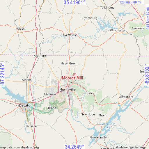
Moores Mill GPS coordinates[2]
34° 50' 38.328" North, 86° 31' 5.952" West
| Map corner | latitude | longitude |
|---|---|---|
| Upper-left | 35.41901°, | -87.22145° |
| Center: | 34.84398°, | -86.51832° |
| Lower-right: | 34.2649°, | -85.8152° |
| Map W x H: | 128.3×128.3 km | = 79.7×79.7mi |
| max Lat: | 71.29058° ⇑76.2% North |
| Moores Mill: | 34.84398° |
| min Lat: | ⇓23.8% South 19.06759° |
| min Long | Moores Mill | max Long |
| -171.73463° | -86.51832° | -66.98998° |
| W 51.5%⇐ | ⇒48.5% E |
Elevation
Elevation of Moores Mill is 206 m = 676 ft, and this is 88.8 m = 291 ft below average elevation for this country.
| Max E: |
3189 m = 10463 ft | 48.1% |
| Avg. | 294.8 m = 967 ft | |
| Moores Mill | 206 m = 676 ft | |
Min E: |
-60 m = -197 ft | 51.9% |
See also: United States elevation on elevation.city.
Geographical zone
Moores Mill is located in North temperate zone (between Tropic of Cancer and the Arctic Circle). Distance of this Northern Tropic circle is 1268.4 km =788.1 mi to South.| Distance of | km | miles | from Moores Mill |
|---|---|---|---|
| North Pole | 6132.8 | 3810.7 | to North |
| Arctic Circle | 3526.9 | 2191.5 | to North |
| Tropic Cancer | 1268.4 | 788.1 | to South |
| Equator | 3874.3 | 2407.4 | to South |


Nearby cities:
15 places around Moores Mill: (largest is in red/bold)
• Ardmore
34.2 km =21.3 mi,  298°
298°
• Brighton
27.2 km =16.9 mi,  15°
15°
• Flintville
25.9 km =16.1 mi, 20°
• Gurley
20.5 km =12.7 mi,  140°
140°
• Harvest
21.3 km =13.2 mi,  273°
273°
• Hazel Green
11 km =6.8 mi,  333°
333°
• Huntland
32.3 km =20.1 mi,  44°
44°
• Huntsville
14.1 km =8.8 mi,  206°
206°
• Madison
26.5 km =16.5 mi,  232°
232°
• Meridianville
5 km =3.1 mi,  279°
279°
• New Market
11.1 km =6.9 mi,  48°
48°
• Owens Cross Roads
29 km =18 mi,  169°
169°
• Park City
26.9 km =16.7 mi,  349°
349°
• Redstone Arsenal
21.4 km =13.3 mi, 213°
• Woodville
32.8 km =20.4 mi, 137°
Sources, notices
• [Note1] Compared only with cities in United States existing in our database
• [Src1] Map data: © OpenStreetMap contributors (CC-BY-SA)
• [Src2] Other city data from geonames.org with taken over terms of usage.
• [Src3] Geographical zone / Annual Mean Temperature by Robert A. Rohde @ Wikipedia
