Huntsville geodata
Huntsville (Alabama) is a seat of a second-order administrative division; located in United States in America/Chicago (GMT-5) time zone. With population of 190,582 people, there are 137 cities with bigger population in this country. Compared to other cities in United States, 76.7% of cities are located further ↑North; 51.3% of cities are located further ←West and 50.5% of cities have lower elevation than Huntsville. Note1


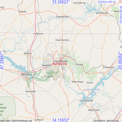
Huntsville GPS coordinates[2]
34° 43' 49.44" North, 86° 35' 9.384" West
| Map corner | latitude | longitude |
|---|---|---|
| Upper-left | 35.30623°, | -87.28907° |
| Center: | 34.7304°, | -86.58594° |
| Lower-right: | 34.15053°, | -85.88282° |
| Map W x H: | 128.5×128.5 km | = 79.8×79.8mi |
| max Lat: | 71.29058° ⇑76.7% North |
| Huntsville: | 34.7304° |
| min Lat: | ⇓23.3% South 19.06759° |
| min Long | Huntsville | max Long |
| -171.73463° | -86.58594° | -66.98998° |
| W 51.3%⇐ | ⇒48.7% E |
Elevation
Elevation of Huntsville is 200 m = 656 ft, and this is 94.8 m = 311 ft below average elevation for this country.
| Max E: |
3189 m = 10463 ft | 49.5% |
| Avg. | 294.8 m = 967 ft | |
| Huntsville | 200 m = 656 ft | |
Min E: |
-60 m = -197 ft | 50.5% |
See also: Huntsville elevation on elevation.city.
Geographical zone
Huntsville is located in North temperate zone (between Tropic of Cancer and the Arctic Circle). Distance of this Northern Tropic circle is 1255.7 km =780.3 mi to South.| Distance of | km | miles | from Huntsville |
|---|---|---|---|
| North Pole | 6145.4 | 3818.6 | to North |
| Arctic Circle | 3539.5 | 2199.3 | to North |
| Tropic Cancer | 1255.7 | 780.3 | to South |
| Equator | 3861.7 | 2399.5 | to South |


Nearby cities:
15 places around Huntsville: (largest is in red/bold)
• Athens
36.2 km =22.5 mi,  282°
282°
• Gurley
19.5 km =12.1 mi,  99°
99°
• Harvest
20.5 km =12.7 mi,  312°
312°
• Hazel Green
22.5 km =14 mi,  3°
3°
• Madison
15.2 km =9.4 mi,  256°
256°
• Meridianville
13.5 km =8.4 mi,  5°
5°
• Moores Mill
14.1 km =8.8 mi,  26°
26°
• New Hope
27.7 km =17.2 mi,  140°
140°
• New Market
24.6 km =15.3 mi,  35°
35°
• Owens Cross Roads
19.6 km =12.2 mi, 143°
• Priceville
36.3 km =22.6 mi,  231°
231°
• Redstone Arsenal
7.7 km =4.8 mi, 227°
• Somerville
34.6 km =21.5 mi,  214°
214°
• Triana
20.9 km =13 mi,  220°
220°
• Woodville
30.7 km =19.1 mi,  111°
111°
Sources, notices
• [Note1] Compared only with cities in United States existing in our database
• [Src1] Map data: © OpenStreetMap contributors (CC-BY-SA)
• [Src2] Other city data from geonames.org with taken over terms of usage.
• [Src3] Geographical zone / Annual Mean Temperature by Robert A. Rohde @ Wikipedia
