Brantley geodata
Brantley (Alabama) is a populated place; located in United States in America/Chicago (GMT-5) time zone. With population of 805 people, there are 17765 cities with bigger population in this country. Compared to other cities in United States, 89.5% of cities are located further ↑North; 52.2% of cities are located further ←West and 71.1% of cities have higher elevation than Brantley. Note1


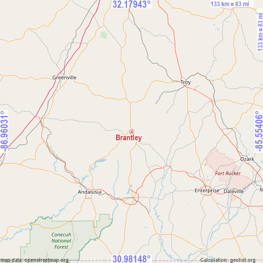
Brantley GPS coordinates[2]
31° 34' 56.568" North, 86° 15' 25.848" West
| Map corner | latitude | longitude |
|---|---|---|
| Upper-left | 32.17943°, | -86.96031° |
| Center: | 31.58238°, | -86.25718° |
| Lower-right: | 30.98148°, | -85.55406° |
| Map W x H: | 133.2×133.2 km | = 82.8×82.8mi |
| max Lat: | 71.29058° ⇑89.5% North |
| Brantley: | 31.58238° |
| min Lat: | ⇓10.5% South 19.06759° |
| min Long | Brantley | max Long |
| -171.73463° | -86.25718° | -66.98998° |
| W 52.2%⇐ | ⇒47.8% E |
Elevation
Elevation of Brantley is 94 m = 308 ft, and this is 200.8 m = 659 ft below average elevation for this country.
| Max E: |
3189 m = 10463 ft | 71.1% |
| Avg. | 294.8 m = 967 ft | |
| Brantley | 94 m = 308 ft | |
Min E: |
-60 m = -197 ft | 28.9% |
See also: United States elevation on elevation.city.
Geographical zone
Brantley is located in North temperate zone (between Tropic of Cancer and the Arctic Circle). Distance of this Northern Tropic circle is 905.7 km =562.8 mi to South.| Distance of | km | miles | from Brantley |
|---|---|---|---|
| North Pole | 6495.4 | 4036.1 | to North |
| Arctic Circle | 3889.5 | 2416.8 | to North |
| Tropic Cancer | 905.7 | 562.8 | to South |
| Equator | 3511.6 | 2182 | to South |


Nearby cities:
15 places around Brantley: (largest is in red/bold)
• Andalusia
37.2 km =23.1 mi,  215°
215°
• Babbie
34.3 km =21.3 mi,  190°
190°
• Brundidge
44.5 km =27.7 mi,  69°
69°
• Elba
25.9 km =16.1 mi,  136°
136°
• Georgiana
46.3 km =28.8 mi,  277°
277°
• Greenville
43.8 km =27.2 mi,  308°
308°
• Joquin
24.3 km =15.1 mi,  21°
21°
• Kinston
41.5 km =25.8 mi,  168°
168°
• Luverne
14.9 km =9.3 mi,  357°
357°
• McKenzie
43.6 km =27.1 mi,  264°
264°
• New Brockton
38 km =23.6 mi,  125°
125°
• Opp
33.3 km =20.7 mi,  179°
179°
• River Falls
37.1 km =23.1 mi,  226°
226°
• Taylor
43.8 km =27.2 mi,  2°
2°
• Troy
37 km =23 mi,  47°
47°
Sources, notices
• [Note1] Compared only with cities in United States existing in our database
• [Src1] Map data: © OpenStreetMap contributors (CC-BY-SA)
• [Src2] Other city data from geonames.org with taken over terms of usage.
• [Src3] Geographical zone / Annual Mean Temperature by Robert A. Rohde @ Wikipedia
