New Site geodata
New Site (Alabama) is a populated place; located in United States in America/Chicago (GMT-5) time zone. With population of 755 people, there are 18177 cities with bigger population in this country. Compared to other cities in United States, 85% of cities are located further ↑North; 53.5% of cities are located further ←West and 66.7% of cities have lower elevation than New Site. Note1


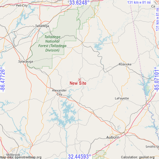
New Site GPS coordinates[2]
33° 2' 14.424" North, 85° 46' 26.868" West
| Map corner | latitude | longitude |
|---|---|---|
| Upper-left | 33.6248°, | -86.47726° |
| Center: | 33.03734°, | -85.77413° |
| Lower-right: | 32.44593°, | -85.07101° |
| Map W x H: | 131.1×131.1 km | = 81.5×81.5mi |
| max Lat: | 71.29058° ⇑85% North |
| New Site: | 33.03734° |
| min Lat: | ⇓15% South 19.06759° |
| min Long | New Site | max Long |
| -171.73463° | -85.77413° | -66.98998° |
| W 53.5%⇐ | ⇒46.5% E |
Elevation
Elevation of New Site is 270 m = 886 ft, and this is 24.8 m = 81 ft below average elevation for this country.
| Max E: |
3189 m = 10463 ft | 33.3% |
| Avg. | 294.8 m = 967 ft | |
| New Site | 270 m = 886 ft | |
Min E: |
-60 m = -197 ft | 66.7% |
See also: United States elevation on elevation.city.
Geographical zone
New Site is located in North temperate zone (between Tropic of Cancer and the Arctic Circle). Distance of this Northern Tropic circle is 1067.5 km =663.3 mi to South.| Distance of | km | miles | from New Site |
|---|---|---|---|
| North Pole | 6333.7 | 3935.6 | to North |
| Arctic Circle | 3727.8 | 2316.3 | to North |
| Tropic Cancer | 1067.5 | 663.3 | to South |
| Equator | 3673.4 | 2282.5 | to South |


Nearby cities:
15 places around New Site: (largest is in red/bold)
• Alexander City
19.7 km =12.2 mi,  238°
238°
• Ashland
26.9 km =16.7 mi,  347°
347°
• Camp Hill
28.6 km =17.8 mi,  156°
156°
• Dadeville
22.9 km =14.2 mi,  177°
177°
• Goodwater
26.2 km =16.3 mi,  276°
276°
• Hissop
38.9 km =24.2 mi,  245°
245°
• Hollins
35.6 km =22.1 mi, 284°
• Jacksons Gap
17.2 km =10.7 mi,  191°
191°
• Lafayette
38 km =23.6 mi,  113°
113°
• Lineville
30.4 km =18.9 mi,  3°
3°
• Our Town
29.1 km =18.1 mi,  216°
216°
• Roanoke
39.5 km =24.5 mi,  71°
71°
• Stewartville
44.1 km =27.4 mi, 276°
• Wadley
21.3 km =13.2 mi,  63°
63°
• Wedowee
40.5 km =25.2 mi,  41°
41°
Sources, notices
• [Note1] Compared only with cities in United States existing in our database
• [Src1] Map data: © OpenStreetMap contributors (CC-BY-SA)
• [Src2] Other city data from geonames.org with taken over terms of usage.
• [Src3] Geographical zone / Annual Mean Temperature by Robert A. Rohde @ Wikipedia
