Wedowee geodata
Wedowee (Alabama) is a seat of a second-order administrative division; located in United States in America/Chicago (GMT-5) time zone. With population of 809 people, there are 17730 cities with bigger population in this country. Compared to other cities in United States, 83.9% of cities are located further ↑North; 54.7% of cities are located further ←West and 64.8% of cities have lower elevation than Wedowee. Note1


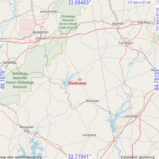
Wedowee GPS coordinates[2]
33° 18' 32.4" North, 85° 29' 4.812" West
| Map corner | latitude | longitude |
|---|---|---|
| Upper-left | 33.89463°, | -86.1878° |
| Center: | 33.309°, | -85.48467° |
| Lower-right: | 32.71941°, | -84.78155° |
| Map W x H: | 130.7×130.7 km | = 81.2×81.2mi |
| max Lat: | 71.29058° ⇑83.9% North |
| Wedowee: | 33.309° |
| min Lat: | ⇓16.1% South 19.06759° |
| min Long | Wedowee | max Long |
| -171.73463° | -85.48467° | -66.98998° |
| W 54.7%⇐ | ⇒45.3% E |
Elevation
Elevation of Wedowee is 261 m = 856 ft, and this is 33.8 m = 111 ft below average elevation for this country.
| Max E: |
3189 m = 10463 ft | 35.2% |
| Avg. | 294.8 m = 967 ft | |
| Wedowee | 261 m = 856 ft | |
Min E: |
-60 m = -197 ft | 64.8% |
See also: United States elevation on elevation.city.
Geographical zone
Wedowee is located in North temperate zone (between Tropic of Cancer and the Arctic Circle). Distance of this Northern Tropic circle is 1097.7 km =682.1 mi to South.| Distance of | km | miles | from Wedowee |
|---|---|---|---|
| North Pole | 6303.4 | 3916.7 | to North |
| Arctic Circle | 3697.6 | 2297.6 | to North |
| Tropic Cancer | 1097.7 | 682.1 | to South |
| Equator | 3703.6 | 2301.3 | to South |


Nearby cities:
15 places around Wedowee: (largest is in red/bold)
• Ashland
32.9 km =20.4 mi,  263°
263°
• Bowdon
33.3 km =20.7 mi,  40°
40°
• Choccolocco
43.9 km =27.3 mi,  332°
332°
• Franklin
36.1 km =22.4 mi,  95°
95°
• Heflin
39 km =24.2 mi,  345°
345°
• Hobson City
48.2 km =30 mi,  316°
316°
• Hollis Crossroads
27.8 km =17.3 mi, 329°
• Lafayette
46.2 km =28.7 mi,  170°
170°
• Lineville
25.1 km =15.6 mi,  270°
270°
• Mount Zion
45.5 km =28.3 mi, 37°
• New Site
40.5 km =25.2 mi,  221°
221°
• Oxford
47 km =29.2 mi, 316°
• Roanoke
20.4 km =12.7 mi,  149°
149°
• Rock Mills
24.7 km =15.3 mi,  132°
132°
• Wadley
22.2 km =13.8 mi,  200°
200°
Sources, notices
• [Note1] Compared only with cities in United States existing in our database
• [Src1] Map data: © OpenStreetMap contributors (CC-BY-SA)
• [Src2] Other city data from geonames.org with taken over terms of usage.
• [Src3] Geographical zone / Annual Mean Temperature by Robert A. Rohde @ Wikipedia
