Dadeville geodata
Dadeville (Alabama) is a seat of a second-order administrative division; located in United States in America/Chicago (GMT-5) time zone. With population of 3,150 people, there are 9379 cities with bigger population in this country. Compared to other cities in United States, 85.8% of cities are located further ↑North; 53.5% of cities are located further ←West and 56.4% of cities have lower elevation than Dadeville. Note1


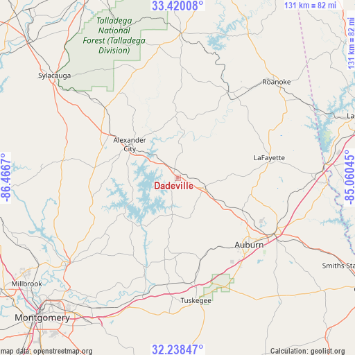
Dadeville GPS coordinates[2]
32° 49' 52.464" North, 85° 45' 48.852" West
| Map corner | latitude | longitude |
|---|---|---|
| Upper-left | 33.42008°, | -86.4667° |
| Center: | 32.83124°, | -85.76357° |
| Lower-right: | 32.23847°, | -85.06045° |
| Map W x H: | 131.4×131.4 km | = 81.6×81.6mi |
| max Lat: | 71.29058° ⇑85.8% North |
| Dadeville: | 32.83124° |
| min Lat: | ⇓14.2% South 19.06759° |
| min Long | Dadeville | max Long |
| -171.73463° | -85.76357° | -66.98998° |
| W 53.5%⇐ | ⇒46.5% E |
Elevation
Elevation of Dadeville is 224 m = 735 ft, and this is 70.8 m = 232 ft below average elevation for this country.
| Max E: |
3189 m = 10463 ft | 43.6% |
| Avg. | 294.8 m = 967 ft | |
| Dadeville | 224 m = 735 ft | |
Min E: |
-60 m = -197 ft | 56.4% |
See also: United States elevation on elevation.city.
Geographical zone
Dadeville is located in North temperate zone (between Tropic of Cancer and the Arctic Circle). Distance of this Northern Tropic circle is 1044.6 km =649.1 mi to South.| Distance of | km | miles | from Dadeville |
|---|---|---|---|
| North Pole | 6356.6 | 3949.8 | to North |
| Arctic Circle | 3750.7 | 2330.6 | to North |
| Tropic Cancer | 1044.6 | 649.1 | to South |
| Equator | 3650.5 | 2268.3 | to South |


Nearby cities:
15 places around Dadeville: (largest is in red/bold)
• Alexander City
21.7 km =13.5 mi,  305°
305°
• Auburn
36.1 km =22.4 mi,  132°
132°
• Camp Hill
10.8 km =6.7 mi,  108°
108°
• Eclectic
33.4 km =20.8 mi,  229°
229°
• Goodwater
37.6 km =23.4 mi, 313°
• Hissop
37 km =23 mi,  280°
280°
• Jacksons Gap
7.6 km =4.7 mi,  323°
323°
• Lafayette
34.7 km =21.6 mi,  77°
77°
• New Site
22.9 km =14.2 mi,  357°
357°
• Notasulga
31.3 km =19.4 mi,  164°
164°
• Opelika
41.5 km =25.8 mi,  119°
119°
• Our Town
18.5 km =11.5 mi,  268°
268°
• Reeltown
25.6 km =15.9 mi,  188°
188°
• Tallassee
35 km =21.7 mi,  200°
200°
• Wadley
37.1 km =23.1 mi,  29°
29°
Sources, notices
• [Note1] Compared only with cities in United States existing in our database
• [Src1] Map data: © OpenStreetMap contributors (CC-BY-SA)
• [Src2] Other city data from geonames.org with taken over terms of usage.
• [Src3] Geographical zone / Annual Mean Temperature by Robert A. Rohde @ Wikipedia
