Jacksons Gap geodata
Jacksons Gap (Alabama) is a populated place; located in United States in America/Chicago (GMT-5) time zone. With population of 828 people, there are 17532 cities with bigger population in this country. Compared to other cities in United States, 85.6% of cities are located further ↑North; 53.4% of cities are located further ←West and 51% of cities have lower elevation than Jacksons Gap. Note1


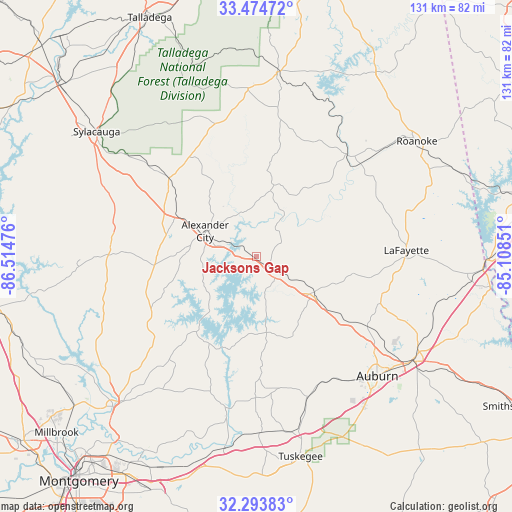
Jacksons Gap GPS coordinates[2]
32° 53' 10.464" North, 85° 48' 41.868" West
| Map corner | latitude | longitude |
|---|---|---|
| Upper-left | 33.47472°, | -86.51476° |
| Center: | 32.88624°, | -85.81163° |
| Lower-right: | 32.29383°, | -85.10851° |
| Map W x H: | 131.3×131.3 km | = 81.6×81.6mi |
| max Lat: | 71.29058° ⇑85.6% North |
| Jacksons Gap: | 32.88624° |
| min Lat: | ⇓14.4% South 19.06759° |
| min Long | Jacksons Gap | max Long |
| -171.73463° | -85.81163° | -66.98998° |
| W 53.4%⇐ | ⇒46.6% E |
Elevation
Elevation of Jacksons Gap is 202 m = 663 ft, and this is 92.8 m = 304 ft below average elevation for this country.
| Max E: |
3189 m = 10463 ft | 49% |
| Avg. | 294.8 m = 967 ft | |
| Jacksons Gap | 202 m = 663 ft | |
Min E: |
-60 m = -197 ft | 51% |
See also: United States elevation on elevation.city.
Geographical zone
Jacksons Gap is located in North temperate zone (between Tropic of Cancer and the Arctic Circle). Distance of this Northern Tropic circle is 1050.7 km =652.9 mi to South.| Distance of | km | miles | from Jacksons Gap |
|---|---|---|---|
| North Pole | 6350.5 | 3946 | to North |
| Arctic Circle | 3744.6 | 2326.8 | to North |
| Tropic Cancer | 1050.7 | 652.9 | to South |
| Equator | 3656.6 | 2272.1 | to South |


Nearby cities:
15 places around Jacksons Gap: (largest is in red/bold)
• Alexander City
14.7 km =9.1 mi,  295°
295°
• Camp Hill
17.6 km =10.9 mi,  122°
122°
• Dadeville
7.6 km =4.7 mi,  143°
143°
• Eclectic
34.8 km =21.6 mi,  216°
216°
• Goodwater
30.1 km =18.7 mi,  311°
311°
• Hissop
31.9 km =19.8 mi,  271°
271°
• Hollins
40.3 km =25 mi, 309°
• Lafayette
38.4 km =23.9 mi,  87°
87°
• New Site
17.2 km =10.7 mi,  11°
11°
• Notasulga
38.5 km =23.9 mi,  160°
160°
• Our Town
15.4 km =9.6 mi,  245°
245°
• Reeltown
31.4 km =19.5 mi,  178°
178°
• Rockford
38.1 km =23.7 mi, 270°
• Tallassee
39.7 km =24.7 mi,  191°
191°
• Wadley
34.7 km =21.6 mi,  40°
40°
Sources, notices
• [Note1] Compared only with cities in United States existing in our database
• [Src1] Map data: © OpenStreetMap contributors (CC-BY-SA)
• [Src2] Other city data from geonames.org with taken over terms of usage.
• [Src3] Geographical zone / Annual Mean Temperature by Robert A. Rohde @ Wikipedia
