Lafayette geodata
Lafayette (Alabama) is a seat of a second-order administrative division; located in United States in America/Chicago (GMT-5) time zone. With population of 3,003 people, there are 9629 cities with bigger population in this country. Compared to other cities in United States, 85.5% of cities are located further ↑North; 54.8% of cities are located further ←West and 65.4% of cities have lower elevation than Lafayette. Note1


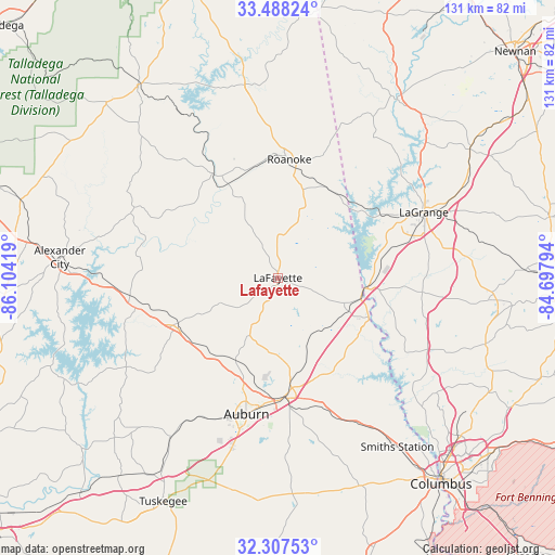
Lafayette GPS coordinates[2]
32° 53' 59.46" North, 85° 24' 3.816" West
| Map corner | latitude | longitude |
|---|---|---|
| Upper-left | 33.48824°, | -86.10419° |
| Center: | 32.89985°, | -85.40106° |
| Lower-right: | 32.30753°, | -84.69794° |
| Map W x H: | 131.3×131.3 km | = 81.6×81.6mi |
| max Lat: | 71.29058° ⇑85.5% North |
| Lafayette: | 32.89985° |
| min Lat: | ⇓14.5% South 19.06759° |
| min Long | Lafayette | max Long |
| -171.73463° | -85.40106° | -66.98998° |
| W 54.8%⇐ | ⇒45.2% E |
Elevation
Elevation of Lafayette is 264 m = 866 ft, and this is 30.8 m = 101 ft below average elevation for this country.
| Max E: |
3189 m = 10463 ft | 34.6% |
| Avg. | 294.8 m = 967 ft | |
| Lafayette | 264 m = 866 ft | |
Min E: |
-60 m = -197 ft | 65.4% |
See also: United States elevation on elevation.city.
Geographical zone
Lafayette is located in North temperate zone (between Tropic of Cancer and the Arctic Circle). Distance of this Northern Tropic circle is 1052.2 km =653.8 mi to South.| Distance of | km | miles | from Lafayette |
|---|---|---|---|
| North Pole | 6348.9 | 3945 | to North |
| Arctic Circle | 3743.1 | 2325.9 | to North |
| Tropic Cancer | 1052.2 | 653.8 | to South |
| Equator | 3658.1 | 2273 | to South |


Nearby cities:
15 places around Lafayette: (largest is in red/bold)
• Auburn
33.1 km =20.6 mi,  193°
193°
• Camp Hill
26 km =16.2 mi,  244°
244°
• Dadeville
34.7 km =21.6 mi,  257°
257°
• Huguley
17.6 km =10.9 mi,  114°
114°
• Jacksons Gap
38.4 km =23.9 mi,  267°
267°
• LaGrange
37.8 km =23.5 mi,  65°
65°
• Lanett
20 km =12.4 mi,  99°
99°
• New Site
38 km =23.6 mi,  293°
293°
• Notasulga
45.5 km =28.3 mi,  213°
213°
• Opelika
28.4 km =17.6 mi,  175°
175°
• Roanoke
28.1 km =17.5 mi,  5°
5°
• Rock Mills
30.8 km =19.1 mi,  20°
20°
• Valley
22.6 km =14 mi, 113°
• Wadley
29.4 km =18.3 mi,  327°
327°
• West Point
20.5 km =12.7 mi, 96°
Sources, notices
• [Note1] Compared only with cities in United States existing in our database
• [Src1] Map data: © OpenStreetMap contributors (CC-BY-SA)
• [Src2] Other city data from geonames.org with taken over terms of usage.
• [Src3] Geographical zone / Annual Mean Temperature by Robert A. Rohde @ Wikipedia
