Russellville geodata
Russellville (Alabama) is a seat of a second-order administrative division; located in United States in America/Chicago (GMT-5) time zone. With population of 9,847 people, there are 4510 cities with bigger population in this country. Compared to other cities in United States, 77.6% of cities are located further ↑North; 51.6% of cities are located further →East and 58.8% of cities have lower elevation than Russellville. Note1


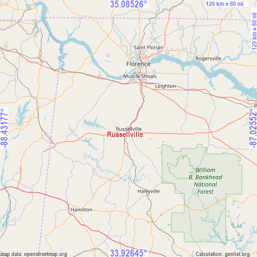
Russellville GPS coordinates[2]
34° 30' 28.332" North, 87° 43' 43.104" West
| Map corner | latitude | longitude |
|---|---|---|
| Upper-left | 35.08526°, | -88.43177° |
| Center: | 34.50787°, | -87.72864° |
| Lower-right: | 33.92645°, | -87.02552° |
| Map W x H: | 128.8×128.8 km | = 80×80mi |
| max Lat: | 71.29058° ⇑77.6% North |
| Russellville: | 34.50787° |
| min Lat: | ⇓22.4% South 19.06759° |
| min Long | Russellville | max Long |
| -171.73463° | -87.72864° | -66.98998° |
| W 48.4%⇐ | ⇒51.6% E |
Elevation
Elevation of Russellville is 234 m = 768 ft, and this is 60.8 m = 199 ft below average elevation for this country.
| Max E: |
3189 m = 10463 ft | 41.2% |
| Avg. | 294.8 m = 967 ft | |
| Russellville | 234 m = 768 ft | |
Min E: |
-60 m = -197 ft | 58.8% |
See also: United States elevation on elevation.city.
Geographical zone
Russellville is located in North temperate zone (between Tropic of Cancer and the Arctic Circle). Distance of this Northern Tropic circle is 1231 km =764.9 mi to South.| Distance of | km | miles | from Russellville |
|---|---|---|---|
| North Pole | 6170.1 | 3833.9 | to North |
| Arctic Circle | 3564.3 | 2214.8 | to North |
| Tropic Cancer | 1231 | 764.9 | to South |
| Equator | 3836.9 | 2384.1 | to South |


Nearby cities:
15 places around Russellville: (largest is in red/bold)
• Bear Creek
26 km =16.2 mi,  174°
174°
• Cherokee
35.6 km =22.1 mi,  321°
321°
• East Florence
34.3 km =21.3 mi,  12°
12°
• Florence
32.8 km =20.4 mi, 8°
• Hackleburg
27.2 km =16.9 mi,  199°
199°
• Haleyville
32.8 km =20.4 mi,  162°
162°
• Leighton
28.2 km =17.5 mi,  40°
40°
• Littleville
10.3 km =6.4 mi,  27°
27°
• Littleville
31.8 km =19.8 mi,  153°
153°
• Muscle Shoals
26.9 km =16.7 mi, 11°
• Phil Campbell
17.6 km =10.9 mi, 173°
• Red Bay
38.5 km =23.9 mi,  258°
258°
• Sheffield
28.7 km =17.8 mi, 5°
• Town Creek
35.3 km =21.9 mi,  56°
56°
• Tuscumbia
24.9 km =15.5 mi, 5°
Sources, notices
• [Note1] Compared only with cities in United States existing in our database
• [Src1] Map data: © OpenStreetMap contributors (CC-BY-SA)
• [Src2] Other city data from geonames.org with taken over terms of usage.
• [Src3] Geographical zone / Annual Mean Temperature by Robert A. Rohde @ Wikipedia
