Tuscumbia geodata
Tuscumbia (Alabama) is a seat of a second-order administrative division; located in United States in America/Chicago (GMT-5) time zone. With population of 8,474 people, there are 5030 cities with bigger population in this country. Compared to other cities in United States, 76.7% of cities are located further ↑North; 51.5% of cities are located further →East and 62.2% of cities have higher elevation than Tuscumbia. Note1


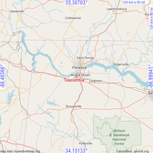
Tuscumbia GPS coordinates[2]
34° 43' 52.32" North, 87° 42' 9.108" West
| Map corner | latitude | longitude |
|---|---|---|
| Upper-left | 35.30703°, | -88.40566° |
| Center: | 34.7312°, | -87.70253° |
| Lower-right: | 34.15133°, | -86.99941° |
| Map W x H: | 128.5×128.5 km | = 79.8×79.8mi |
| max Lat: | 71.29058° ⇑76.7% North |
| Tuscumbia: | 34.7312° |
| min Lat: | ⇓23.3% South 19.06759° |
| min Long | Tuscumbia | max Long |
| -171.73463° | -87.70253° | -66.98998° |
| W 48.5%⇐ | ⇒51.5% E |
Elevation
Elevation of Tuscumbia is 143 m = 469 ft, and this is 151.8 m = 498 ft below average elevation for this country.
| Max E: |
3189 m = 10463 ft | 62.2% |
| Avg. | 294.8 m = 967 ft | |
| Tuscumbia | 143 m = 469 ft | |
Min E: |
-60 m = -197 ft | 37.8% |
See also: United States elevation on elevation.city.
Geographical zone
Tuscumbia is located in North temperate zone (between Tropic of Cancer and the Arctic Circle). Distance of this Northern Tropic circle is 1255.8 km =780.3 mi to South.| Distance of | km | miles | from Tuscumbia |
|---|---|---|---|
| North Pole | 6145.3 | 3818.5 | to North |
| Arctic Circle | 3539.4 | 2199.3 | to North |
| Tropic Cancer | 1255.8 | 780.3 | to South |
| Equator | 3861.7 | 2399.5 | to South |


Nearby cities:
15 places around Tuscumbia: (largest is in red/bold)
• Cherokee
24.9 km =15.5 mi,  276°
276°
• Courtland
36.6 km =22.7 mi,  100°
100°
• East Florence
10 km =6.2 mi,  29°
29°
• Florence
8 km =5 mi,  16°
16°
• Killen
21 km =13 mi,  45°
45°
• Leighton
16.2 km =10.1 mi, 101°
• Littleville
15.8 km =9.8 mi,  171°
171°
• Muscle Shoals
3.5 km =2.2 mi,  64°
64°
• North Courtland
34.7 km =21.6 mi, 100°
• Rogersville
38.5 km =23.9 mi,  74°
74°
• Russellville
24.9 km =15.5 mi,  185°
185°
• Saint Joseph
38.3 km =23.8 mi, 27°
• Sheffield
3.8 km =2.4 mi,  5°
5°
• Town Creek
27.7 km =17.2 mi, 101°
• Underwood-Petersville
16.2 km =10.1 mi,  1°
1°
Sources, notices
• [Note1] Compared only with cities in United States existing in our database
• [Src1] Map data: © OpenStreetMap contributors (CC-BY-SA)
• [Src2] Other city data from geonames.org with taken over terms of usage.
• [Src3] Geographical zone / Annual Mean Temperature by Robert A. Rohde @ Wikipedia
