Florence geodata
Florence (Alabama) is a seat of a second-order administrative division; located in United States in America/Chicago (GMT-5) time zone. With population of 40,026 people, there are 1208 cities with bigger population in this country. Compared to other cities in United States, 76.4% of cities are located further ↑North; 51.3% of cities are located further →East and 56.8% of cities have higher elevation than Florence. Note1


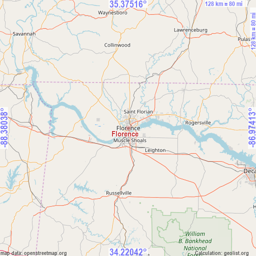
Florence GPS coordinates[2]
34° 47' 59.316" North, 87° 40' 38.1" West
| Map corner | latitude | longitude |
|---|---|---|
| Upper-left | 35.37516°, | -88.38038° |
| Center: | 34.79981°, | -87.67725° |
| Lower-right: | 34.22042°, | -86.97413° |
| Map W x H: | 128.4×128.4 km | = 79.8×79.8mi |
| max Lat: | 71.29058° ⇑76.4% North |
| Florence: | 34.79981° |
| min Lat: | ⇓23.6% South 19.06759° |
| min Long | Florence | max Long |
| -171.73463° | -87.67725° | -66.98998° |
| W 48.7%⇐ | ⇒51.3% E |
Elevation
Elevation of Florence is 172 m = 564 ft, and this is 122.8 m = 403 ft below average elevation for this country.
| Max E: |
3189 m = 10463 ft | 56.8% |
| Avg. | 294.8 m = 967 ft | |
| Florence | 172 m = 564 ft | |
Min E: |
-60 m = -197 ft | 43.2% |
See also: Florence elevation on elevation.city.
Geographical zone
Florence is located in North temperate zone (between Tropic of Cancer and the Arctic Circle). Distance of this Northern Tropic circle is 1263.5 km =785.1 mi to South.| Distance of | km | miles | from Florence |
|---|---|---|---|
| North Pole | 6137.7 | 3813.8 | to North |
| Arctic Circle | 3531.8 | 2194.6 | to North |
| Tropic Cancer | 1263.5 | 785.1 | to South |
| Equator | 3869.4 | 2404.3 | to South |


Nearby cities:
15 places around Florence: (largest is in red/bold)
• Cherokee
27.4 km =17 mi,  260°
260°
• East Florence
2.8 km =1.7 mi,  66°
66°
• Killen
14.6 km =9.1 mi,  61°
61°
• Leighton
17.5 km =10.9 mi,  129°
129°
• Lexington
33.7 km =20.9 mi, 55°
• Littleville
23.3 km =14.5 mi,  179°
179°
• Muscle Shoals
6.2 km =3.9 mi,  171°
171°
• North Courtland
34.8 km =21.6 mi,  114°
114°
• Rogersville
34.9 km =21.7 mi,  85°
85°
• Russellville
32.8 km =20.4 mi,  188°
188°
• Saint Joseph
30.5 km =19 mi,  30°
30°
• Sheffield
4.3 km =2.7 mi,  206°
206°
• Town Creek
28.1 km =17.5 mi,  118°
118°
• Tuscumbia
8 km =5 mi,  196°
196°
• Underwood-Petersville
8.8 km =5.5 mi,  348°
348°
Sources, notices
• [Note1] Compared only with cities in United States existing in our database
• [Src1] Map data: © OpenStreetMap contributors (CC-BY-SA)
• [Src2] Other city data from geonames.org with taken over terms of usage.
• [Src3] Geographical zone / Annual Mean Temperature by Robert A. Rohde @ Wikipedia
