Sheffield geodata
Sheffield (Alabama) is a populated place; located in United States in America/Chicago (GMT-5) time zone. With population of 9,108 people, there are 4761 cities with bigger population in this country. Compared to other cities in United States, 76.5% of cities are located further ↑North; 51.5% of cities are located further →East and 59% of cities have higher elevation than Sheffield. Note1


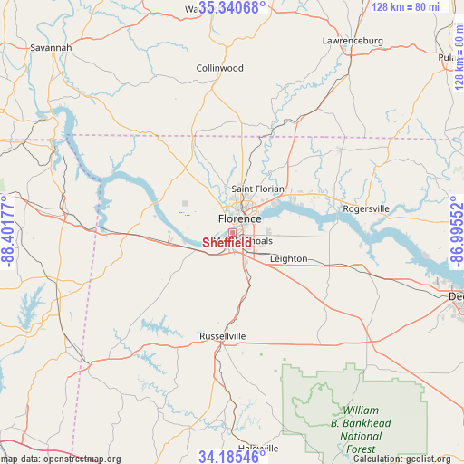
Sheffield GPS coordinates[2]
34° 45' 54.324" North, 87° 41' 55.104" West
| Map corner | latitude | longitude |
|---|---|---|
| Upper-left | 35.34068°, | -88.40177° |
| Center: | 34.76509°, | -87.69864° |
| Lower-right: | 34.18546°, | -86.99552° |
| Map W x H: | 128.4×128.4 km | = 79.8×79.8mi |
| max Lat: | 71.29058° ⇑76.5% North |
| Sheffield: | 34.76509° |
| min Lat: | ⇓23.5% South 19.06759° |
| min Long | Sheffield | max Long |
| -171.73463° | -87.69864° | -66.98998° |
| W 48.5%⇐ | ⇒51.5% E |
Elevation
Elevation of Sheffield is 160 m = 525 ft, and this is 134.8 m = 442 ft below average elevation for this country.
| Max E: |
3189 m = 10463 ft | 59% |
| Avg. | 294.8 m = 967 ft | |
| Sheffield | 160 m = 525 ft | |
Min E: |
-60 m = -197 ft | 41% |
See also: United States elevation on elevation.city.
Geographical zone
Sheffield is located in North temperate zone (between Tropic of Cancer and the Arctic Circle). Distance of this Northern Tropic circle is 1259.6 km =782.7 mi to South.| Distance of | km | miles | from Sheffield |
|---|---|---|---|
| North Pole | 6141.5 | 3816.1 | to North |
| Arctic Circle | 3535.7 | 2197 | to North |
| Tropic Cancer | 1259.6 | 782.7 | to South |
| Equator | 3865.5 | 2401.9 | to South |


Nearby cities:
15 places around Sheffield: (largest is in red/bold)
• Cherokee
25.1 km =15.6 mi,  267°
267°
• Courtland
37.1 km =23.1 mi,  106°
106°
• East Florence
6.7 km =4.2 mi,  42°
42°
• Florence
4.3 km =2.7 mi,  26°
26°
• Killen
18.3 km =11.4 mi,  53°
53°
• Leighton
17.1 km =10.6 mi, 114°
• Littleville
19.5 km =12.1 mi,  174°
174°
• Muscle Shoals
3.6 km =2.2 mi,  128°
128°
• North Courtland
35.3 km =21.9 mi, 107°
• Rogersville
37.3 km =23.2 mi,  79°
79°
• Russellville
28.7 km =17.8 mi,  185°
185°
• Saint Joseph
34.9 km =21.7 mi, 30°
• Town Creek
28.3 km =17.6 mi, 109°
• Tuscumbia
3.8 km =2.4 mi, 185°
• Underwood-Petersville
12.4 km =7.7 mi,  0°
0°
Sources, notices
• [Note1] Compared only with cities in United States existing in our database
• [Src1] Map data: © OpenStreetMap contributors (CC-BY-SA)
• [Src2] Other city data from geonames.org with taken over terms of usage.
• [Src3] Geographical zone / Annual Mean Temperature by Robert A. Rohde @ Wikipedia
