Cherokee geodata
Cherokee (Alabama) is a populated place; located in United States in America/Chicago (GMT-5) time zone. With population of 1,014 people, there are 16188 cities with bigger population in this country. Compared to other cities in United States, 76.6% of cities are located further ↑North; 52.7% of cities are located further →East and 58.8% of cities have higher elevation than Cherokee. Note1


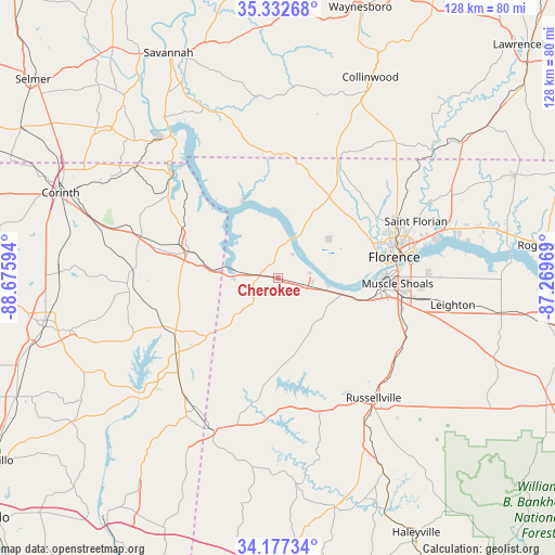
Cherokee GPS coordinates[2]
34° 45' 25.308" North, 87° 58' 22.116" West
| Map corner | latitude | longitude |
|---|---|---|
| Upper-left | 35.33268°, | -88.67594° |
| Center: | 34.75703°, | -87.97281° |
| Lower-right: | 34.17734°, | -87.26969° |
| Map W x H: | 128.5×128.5 km | = 79.8×79.8mi |
| max Lat: | 71.29058° ⇑76.6% North |
| Cherokee: | 34.75703° |
| min Lat: | ⇓23.4% South 19.06759° |
| min Long | Cherokee | max Long |
| -171.73463° | -87.97281° | -66.98998° |
| W 47.3%⇐ | ⇒52.7% E |
Elevation
Elevation of Cherokee is 161 m = 528 ft, and this is 133.8 m = 439 ft below average elevation for this country.
| Max E: |
3189 m = 10463 ft | 58.8% |
| Avg. | 294.8 m = 967 ft | |
| Cherokee | 161 m = 528 ft | |
Min E: |
-60 m = -197 ft | 41.2% |
See also: United States elevation on elevation.city.
Geographical zone
Cherokee is located in North temperate zone (between Tropic of Cancer and the Arctic Circle). Distance of this Northern Tropic circle is 1258.7 km =782.1 mi to South.| Distance of | km | miles | from Cherokee |
|---|---|---|---|
| North Pole | 6142.4 | 3816.7 | to North |
| Arctic Circle | 3536.6 | 2197.5 | to North |
| Tropic Cancer | 1258.7 | 782.1 | to South |
| Equator | 3864.6 | 2401.4 | to South |


Nearby cities:
15 places around Cherokee: (largest is in red/bold)
• Belmont
35 km =21.7 mi,  218°
218°
• Burnsville
32.6 km =20.3 mi,  286°
286°
• East Florence
30.1 km =18.7 mi,  78°
78°
• Farmington
47.8 km =29.7 mi, 293°
• Florence
27.4 km =17 mi, 80°
• Iuka
20.7 km =12.9 mi, 287°
• Killen
41.4 km =25.7 mi,  73°
73°
• Leighton
41 km =25.5 mi,  98°
98°
• Littleville
32.8 km =20.4 mi,  124°
124°
• Muscle Shoals
27.9 km =17.3 mi,  92°
92°
• Red Bay
38.5 km =23.9 mi,  203°
203°
• Russellville
35.6 km =22.1 mi,  141°
141°
• Sheffield
25.1 km =15.6 mi, 87°
• Tuscumbia
24.9 km =15.5 mi, 96°
• Underwood-Petersville
28.5 km =17.7 mi,  62°
62°
Sources, notices
• [Note1] Compared only with cities in United States existing in our database
• [Src1] Map data: © OpenStreetMap contributors (CC-BY-SA)
• [Src2] Other city data from geonames.org with taken over terms of usage.
• [Src3] Geographical zone / Annual Mean Temperature by Robert A. Rohde @ Wikipedia
