Uniontown geodata
Uniontown (Alabama) is a populated place; located in United States in America/Chicago (GMT-5) time zone. With population of 2,415 people, there are 10812 cities with bigger population in this country. Compared to other cities in United States, 87.3% of cities are located further ↑North; 50.8% of cities are located further →East and 71.5% of cities have higher elevation than Uniontown. Note1


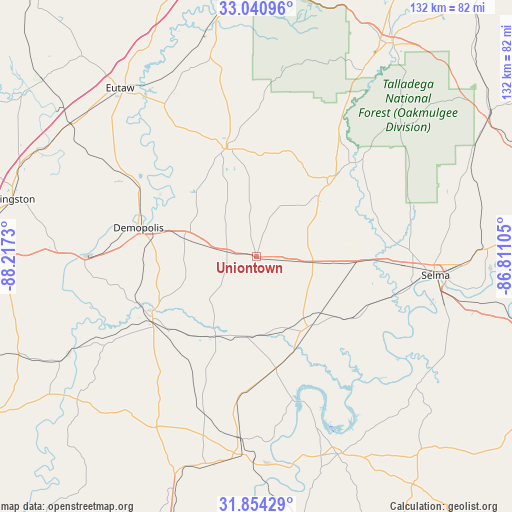
Uniontown GPS coordinates[2]
32° 26' 58.488" North, 87° 30' 51.012" West
| Map corner | latitude | longitude |
|---|---|---|
| Upper-left | 33.04096°, | -88.2173° |
| Center: | 32.44958°, | -87.51417° |
| Lower-right: | 31.85429°, | -86.81105° |
| Map W x H: | 131.9×131.9 km | = 82×82mi |
| max Lat: | 71.29058° ⇑87.3% North |
| Uniontown: | 32.44958° |
| min Lat: | ⇓12.7% South 19.06759° |
| min Long | Uniontown | max Long |
| -171.73463° | -87.51417° | -66.98998° |
| W 49.2%⇐ | ⇒50.8% E |
Elevation
Elevation of Uniontown is 92 m = 302 ft, and this is 202.8 m = 665 ft below average elevation for this country.
| Max E: |
3189 m = 10463 ft | 71.5% |
| Avg. | 294.8 m = 967 ft | |
| Uniontown | 92 m = 302 ft | |
Min E: |
-60 m = -197 ft | 28.5% |
See also: United States elevation on elevation.city.
Geographical zone
Uniontown is located in North temperate zone (between Tropic of Cancer and the Arctic Circle). Distance of this Northern Tropic circle is 1002.1 km =622.7 mi to South.| Distance of | km | miles | from Uniontown |
|---|---|---|---|
| North Pole | 6399 | 3976.2 | to North |
| Arctic Circle | 3793.1 | 2356.9 | to North |
| Tropic Cancer | 1002.1 | 622.7 | to South |
| Equator | 3608.1 | 2242 | to South |


Nearby cities:
15 places around Uniontown: (largest is in red/bold)
• Bellamy
58.1 km =36.1 mi,  269°
269°
• Brent
63.3 km =39.3 mi,  31°
31°
• Camden
55.2 km =34.3 mi,  157°
157°
• Demopolis
31.2 km =19.4 mi,  284°
284°
• Eutaw
55.8 km =34.7 mi,  321°
321°
• Forkland
41 km =25.5 mi,  302°
302°
• Greensboro
29.3 km =18.2 mi,  344°
344°
• Linden
31.1 km =19.3 mi,  239°
239°
• Marion
27.3 km =17 mi,  41°
41°
• Moundville
61.9 km =38.5 mi,  349°
349°
• Pine Hill
52.7 km =32.7 mi,  187°
187°
• Selma
46.5 km =28.9 mi,  95°
95°
• Selmont-West Selmont
48.2 km =30 mi, 99°
• Thomasville
63.2 km =39.3 mi,  199°
199°
• Valley Grande
49.8 km =30.9 mi,  82°
82°
Sources, notices
• [Note1] Compared only with cities in United States existing in our database
• [Src1] Map data: © OpenStreetMap contributors (CC-BY-SA)
• [Src2] Other city data from geonames.org with taken over terms of usage.
• [Src3] Geographical zone / Annual Mean Temperature by Robert A. Rohde @ Wikipedia
