Camden geodata
Camden (Alabama) is a seat of a second-order administrative division; located in United States in America/Chicago (GMT-5) time zone. With population of 1,930 people, there are 12152 cities with bigger population in this country. Compared to other cities in United States, 88.6% of cities are located further ↑North; 50.3% of cities are located further →East and 76% of cities have higher elevation than Camden. Note1


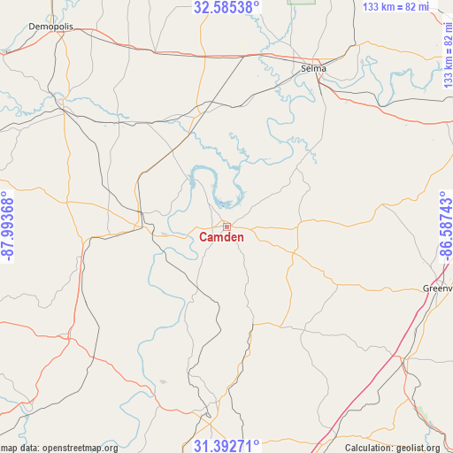
Camden GPS coordinates[2]
31° 59' 27.528" North, 87° 17' 25.98" West
| Map corner | latitude | longitude |
|---|---|---|
| Upper-left | 32.58538°, | -87.99368° |
| Center: | 31.99098°, | -87.29055° |
| Lower-right: | 31.39271°, | -86.58743° |
| Map W x H: | 132.6×132.6 km | = 82.4×82.4mi |
| max Lat: | 71.29058° ⇑88.6% North |
| Camden: | 31.99098° |
| min Lat: | ⇓11.4% South 19.06759° |
| min Long | Camden | max Long |
| -171.73463° | -87.29055° | -66.98998° |
| W 49.7%⇐ | ⇒50.3% E |
Elevation
Elevation of Camden is 66 m = 217 ft, and this is 228.8 m = 751 ft below average elevation for this country.
| Max E: |
3189 m = 10463 ft | 76% |
| Avg. | 294.8 m = 967 ft | |
| Camden | 66 m = 217 ft | |
Min E: |
-60 m = -197 ft | 24% |
See also: United States elevation on elevation.city.
Geographical zone
Camden is located in North temperate zone (between Tropic of Cancer and the Arctic Circle). Distance of this Northern Tropic circle is 951.1 km =591 mi to South.| Distance of | km | miles | from Camden |
|---|---|---|---|
| North Pole | 6450 | 4007.8 | to North |
| Arctic Circle | 3844.1 | 2388.6 | to North |
| Tropic Cancer | 951.1 | 591 | to South |
| Equator | 3557.1 | 2210.3 | to South |


Nearby cities:
15 places around Camden: (largest is in red/bold)
• Excel
62.8 km =39 mi,  184°
184°
• Frisco City
62.9 km =39.1 mi,  189°
189°
• Georgiana
65.1 km =40.5 mi,  127°
127°
• Greenville
66 km =41 mi,  105°
105°
• Grove Hill
55.7 km =34.6 mi,  235°
235°
• Linden
59.3 km =36.8 mi,  306°
306°
• Monroeville
51.6 km =32.1 mi, 183°
• Mosses
61.8 km =38.4 mi,  70°
70°
• Pine Hill
28.1 km =17.5 mi,  267°
267°
• Selma
52.8 km =32.8 mi,  28°
28°
• Selmont-West Selmont
50.7 km =31.5 mi, 31°
• Thomasville
42.9 km =26.7 mi,  258°
258°
• Uniontown
55.2 km =34.3 mi,  337°
337°
• Valley Grande
64.3 km =40 mi, 26°
• White Hall
66.1 km =41.1 mi,  55°
55°
Sources, notices
• [Note1] Compared only with cities in United States existing in our database
• [Src1] Map data: © OpenStreetMap contributors (CC-BY-SA)
• [Src2] Other city data from geonames.org with taken over terms of usage.
• [Src3] Geographical zone / Annual Mean Temperature by Robert A. Rohde @ Wikipedia
