Selma geodata
Selma (Alabama) is a seat of a second-order administrative division; located in United States in America/Chicago (GMT-5) time zone. With population of 19,519 people, there are 2572 cities with bigger population in this country. Compared to other cities in United States, 87.5% of cities are located further ↑North; 50.3% of cities are located further ←West and 80.3% of cities have higher elevation than Selma. Note1


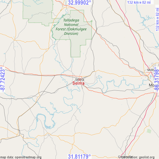
Selma GPS coordinates[2]
32° 24' 26.496" North, 87° 1' 15.96" West
| Map corner | latitude | longitude |
|---|---|---|
| Upper-left | 32.99902°, | -87.72423° |
| Center: | 32.40736°, | -87.0211° |
| Lower-right: | 31.81179°, | -86.31798° |
| Map W x H: | 132×132 km | = 82×82mi |
| max Lat: | 71.29058° ⇑87.5% North |
| Selma: | 32.40736° |
| min Lat: | ⇓12.5% South 19.06759° |
| min Long | Selma | max Long |
| -171.73463° | -87.0211° | -66.98998° |
| W 50.3%⇐ | ⇒49.7% E |
Elevation
Elevation of Selma is 45 m = 148 ft, and this is 249.8 m = 820 ft below average elevation for this country.
| Max E: |
3189 m = 10463 ft | 80.3% |
| Avg. | 294.8 m = 967 ft | |
| Selma | 45 m = 148 ft | |
Min E: |
-60 m = -197 ft | 19.7% |
See also: United States elevation on elevation.city.
Geographical zone
Selma is located in North temperate zone (between Tropic of Cancer and the Arctic Circle). Distance of this Northern Tropic circle is 997.4 km =619.8 mi to South.| Distance of | km | miles | from Selma |
|---|---|---|---|
| North Pole | 6403.7 | 3979.1 | to North |
| Arctic Circle | 3797.8 | 2359.8 | to North |
| Tropic Cancer | 997.4 | 619.8 | to South |
| Equator | 3603.4 | 2239 | to South |


Nearby cities:
15 places around Selma: (largest is in red/bold)
• Autaugaville
34.5 km =21.4 mi,  85°
85°
• Brent
60.4 km =37.5 mi,  347°
347°
• Camden
52.8 km =32.8 mi,  208°
208°
• Centreville
60.6 km =37.7 mi, 351°
• Clanton
60.4 km =37.5 mi,  37°
37°
• Hayneville
48.3 km =30 mi,  120°
120°
• Maplesville
44.6 km =27.7 mi,  18°
18°
• Marion
37.5 km =23.3 mi,  311°
311°
• Mosses
41.8 km =26 mi,  128°
128°
• Pine Level
55.7 km =34.6 mi,  69°
69°
• Prattville
53.1 km =33 mi,  83°
83°
• Selmont-West Selmont
3.5 km =2.2 mi,  158°
158°
• Uniontown
46.5 km =28.9 mi,  275°
275°
• Valley Grande
11.7 km =7.3 mi, 15°
• White Hall
30.4 km =18.9 mi,  107°
107°
Sources, notices
• [Note1] Compared only with cities in United States existing in our database
• [Src1] Map data: © OpenStreetMap contributors (CC-BY-SA)
• [Src2] Other city data from geonames.org with taken over terms of usage.
• [Src3] Geographical zone / Annual Mean Temperature by Robert A. Rohde @ Wikipedia
