Selmont-West Selmont geodata
Selmont-West Selmont (Alabama) is a populated place; located in United States in America/Chicago (GMT-5) time zone. With population of 2,671 people, there are 10237 cities with bigger population in this country. Compared to other cities in United States, 87.6% of cities are located further ↑North; 50.3% of cities are located further ←West and 82.9% of cities have higher elevation than Selmont-West Selmont. Note1


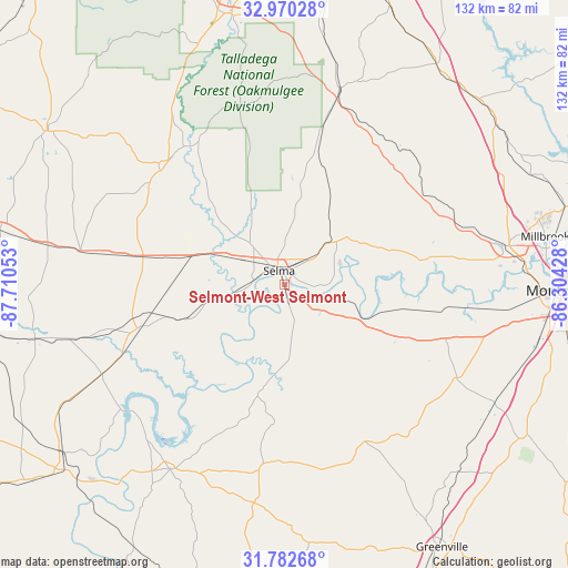
Selmont-West Selmont GPS coordinates[2]
32° 22' 42.348" North, 87° 0' 26.64" West
| Map corner | latitude | longitude |
|---|---|---|
| Upper-left | 32.97028°, | -87.71053° |
| Center: | 32.37843°, | -87.0074° |
| Lower-right: | 31.78268°, | -86.30428° |
| Map W x H: | 132×132 km | = 82×82mi |
| max Lat: | 71.29058° ⇑87.6% North |
| Selmont-West Selmont: | 32.37843° |
| min Lat: | ⇓12.4% South 19.06759° |
| min Long | Selmont-West Se | max Long |
| -171.73463° | -87.0074° | -66.98998° |
| W 50.3%⇐ | ⇒49.7% E |
Elevation
Elevation of Selmont-West Selmont is 35 m = 115 ft, and this is 259.8 m = 852 ft below average elevation for this country.
| Max E: |
3189 m = 10463 ft | 82.9% |
| Avg. | 294.8 m = 967 ft | |
| Selmont-West Selmont | 35 m = 115 ft | |
Min E: |
-60 m = -197 ft | 17.1% |
See also: United States elevation on elevation.city.
Geographical zone
Selmont-West Selmont is located in North temperate zone (between Tropic of Cancer and the Arctic Circle). Distance of this Northern Tropic circle is 994.2 km =617.8 mi to South.| Distance of | km | miles | from Selmont-West Selmont |
|---|---|---|---|
| North Pole | 6406.9 | 3981.1 | to North |
| Arctic Circle | 3801 | 2361.8 | to North |
| Tropic Cancer | 994.2 | 617.8 | to South |
| Equator | 3600.1 | 2237 | to South |


Nearby cities:
15 places around Selmont-West Selmont: (largest is in red/bold)
• Autaugaville
33.7 km =20.9 mi,  79°
79°
• Camden
50.7 km =31.5 mi,  211°
211°
• Fort Deposit
59.5 km =37 mi,  137°
137°
• Hayneville
45.6 km =28.3 mi,  118°
118°
• Maplesville
47.3 km =29.4 mi,  15°
15°
• Marbury
61.8 km =38.4 mi,  54°
54°
• Marion
40.6 km =25.2 mi,  314°
314°
• Millbrook
61.6 km =38.3 mi, 79°
• Mosses
38.8 km =24.1 mi,  125°
125°
• Pine Level
55.7 km =34.6 mi,  65°
65°
• Prattville
52.3 km =32.5 mi, 79°
• Selma
3.5 km =2.2 mi,  338°
338°
• Uniontown
48.2 km =30 mi,  279°
279°
• Valley Grande
14.6 km =9.1 mi,  7°
7°
• White Hall
28.3 km =17.6 mi,  101°
101°
Sources, notices
• [Note1] Compared only with cities in United States existing in our database
• [Src1] Map data: © OpenStreetMap contributors (CC-BY-SA)
• [Src2] Other city data from geonames.org with taken over terms of usage.
• [Src3] Geographical zone / Annual Mean Temperature by Robert A. Rohde @ Wikipedia
