Rock Mills geodata
Rock Mills (Alabama) is a populated place; located in United States in America/Chicago (GMT-5) time zone. With population of 600 people, there are 19702 cities with bigger population in this country. Compared to other cities in United States, 84.5% of cities are located further ↑North; 55.1% of cities are located further ←West and 59.9% of cities have lower elevation than Rock Mills. Note1


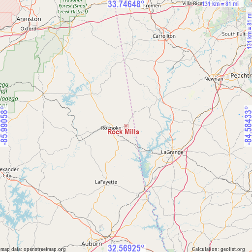
Rock Mills GPS coordinates[2]
33° 9' 35.424" North, 85° 17' 14.82" West
| Map corner | latitude | longitude |
|---|---|---|
| Upper-left | 33.74648°, | -85.99058° |
| Center: | 33.15984°, | -85.28745° |
| Lower-right: | 32.56925°, | -84.58433° |
| Map W x H: | 130.9×130.9 km | = 81.3×81.3mi |
| max Lat: | 71.29058° ⇑84.5% North |
| Rock Mills: | 33.15984° |
| min Lat: | ⇓15.5% South 19.06759° |
| min Long | Rock Mills | max Long |
| -171.73463° | -85.28745° | -66.98998° |
| W 55.1%⇐ | ⇒44.9% E |
Elevation
Elevation of Rock Mills is 239 m = 784 ft, and this is 55.8 m = 183 ft below average elevation for this country.
| Max E: |
3189 m = 10463 ft | 40.1% |
| Avg. | 294.8 m = 967 ft | |
| Rock Mills | 239 m = 784 ft | |
Min E: |
-60 m = -197 ft | 59.9% |
See also: United States elevation on elevation.city.
Geographical zone
Rock Mills is located in North temperate zone (between Tropic of Cancer and the Arctic Circle). Distance of this Northern Tropic circle is 1081.1 km =671.8 mi to South.| Distance of | km | miles | from Rock Mills |
|---|---|---|---|
| North Pole | 6320 | 3927.1 | to North |
| Arctic Circle | 3714.1 | 2307.8 | to North |
| Tropic Cancer | 1081.1 | 671.8 | to South |
| Equator | 3687 | 2291 | to South |


Nearby cities:
15 places around Rock Mills: (largest is in red/bold)
• Bowdon
42.2 km =26.2 mi,  4°
4°
• Franklin
22 km =13.7 mi,  53°
53°
• Grantville
42.8 km =26.6 mi,  78°
78°
• Hogansville
34.7 km =21.6 mi,  87°
87°
• Huguley
36.6 km =22.7 mi,  171°
171°
• LaGrange
27.4 km =17 mi,  119°
119°
• Lafayette
30.8 km =19.1 mi,  200°
200°
• Lanett
33.6 km =20.9 mi,  164°
164°
• Lineville
46.6 km =29 mi,  291°
291°
• New Site
47.3 km =29.4 mi,  253°
253°
• Roanoke
7.9 km =4.9 mi,  263°
263°
• Valley
39.2 km =24.4 mi, 165°
• Wadley
26.6 km =16.5 mi, 261°
• Wedowee
24.7 km =15.3 mi,  312°
312°
• West Point
32.8 km =20.4 mi, 162°
Sources, notices
• [Note1] Compared only with cities in United States existing in our database
• [Src1] Map data: © OpenStreetMap contributors (CC-BY-SA)
• [Src2] Other city data from geonames.org with taken over terms of usage.
• [Src3] Geographical zone / Annual Mean Temperature by Robert A. Rohde @ Wikipedia
