Dermott geodata
Dermott (Arkansas) is a populated place; located in United States in America/Chicago (GMT-5) time zone. With population of 2,720 people, there are 10139 cities with bigger population in this country. Compared to other cities in United States, 83% of cities are located further ↑North; 63% of cities are located further →East and 80.1% of cities have higher elevation than Dermott. Note1


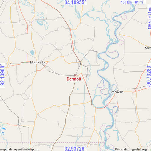
Dermott GPS coordinates[2]
33° 31' 31.404" North, 91° 26' 9.42" West
| Map corner | latitude | longitude |
|---|---|---|
| Upper-left | 34.10955°, | -92.13908° |
| Center: | 33.52539°, | -91.43595° |
| Lower-right: | 32.93726°, | -90.73283° |
| Map W x H: | 130.3×130.3 km | = 81×81mi |
| max Lat: | 71.29058° ⇑83% North |
| Dermott: | 33.52539° |
| min Lat: | ⇓17% South 19.06759° |
| min Long | Dermott | max Long |
| -171.73463° | -91.43595° | -66.98998° |
| W 37%⇐ | ⇒63% E |
Elevation
Elevation of Dermott is 46 m = 151 ft, and this is 248.8 m = 816 ft below average elevation for this country.
| Max E: |
3189 m = 10463 ft | 80.1% |
| Avg. | 294.8 m = 967 ft | |
| Dermott | 46 m = 151 ft | |
Min E: |
-60 m = -197 ft | 19.9% |
See also: United States elevation on elevation.city.
Geographical zone
Dermott is located in North temperate zone (between Tropic of Cancer and the Arctic Circle). Distance of this Northern Tropic circle is 1121.8 km =697.1 mi to South.| Distance of | km | miles | from Dermott |
|---|---|---|---|
| North Pole | 6279.4 | 3901.8 | to North |
| Arctic Circle | 3673.5 | 2282.6 | to North |
| Tropic Cancer | 1121.8 | 697.1 | to South |
| Equator | 3727.7 | 2316.3 | to South |


Nearby cities:
15 places around Dermott: (largest is in red/bold)
• Arkansas City
23.2 km =14.4 mi,  66°
66°
• Dumas
40.5 km =25.2 mi,  352°
352°
• Eudora
49 km =30.4 mi,  160°
160°
• Gould
52.4 km =32.6 mi, 347°
• Greenville
37.2 km =23.1 mi,  110°
110°
• Hamburg
47.1 km =29.3 mi,  225°
225°
• Lake Village
26.1 km =16.2 mi,  146°
146°
• Leland
51.7 km =32.1 mi,  104°
104°
• McGehee
12 km =7.5 mi,  16°
16°
• Metcalfe
40.5 km =25.2 mi, 101°
• Monticello
34.8 km =21.6 mi,  289°
289°
• Pea Ridge
44.9 km =27.9 mi,  11°
11°
• Rosedale
52.5 km =32.6 mi,  45°
45°
• Wilmar
47.3 km =29.4 mi,  284°
284°
• Wilmot
53.6 km =33.3 mi,  193°
193°
Sources, notices
• [Note1] Compared only with cities in United States existing in our database
• [Src1] Map data: © OpenStreetMap contributors (CC-BY-SA)
• [Src2] Other city data from geonames.org with taken over terms of usage.
• [Src3] Geographical zone / Annual Mean Temperature by Robert A. Rohde @ Wikipedia
