Gould geodata
Gould (Arkansas) is a populated place; located in United States in America/Chicago (GMT-5) time zone. With population of 778 people, there are 17996 cities with bigger population in this country. Compared to other cities in United States, 80.3% of cities are located further ↑North; 63.2% of cities are located further →East and 79% of cities have higher elevation than Gould. Note1


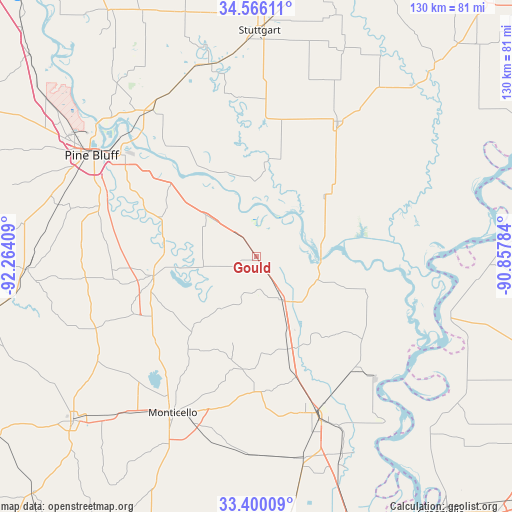
Gould GPS coordinates[2]
33° 59' 6.36" North, 91° 33' 39.456" West
| Map corner | latitude | longitude |
|---|---|---|
| Upper-left | 34.56611°, | -92.26409° |
| Center: | 33.9851°, | -91.56096° |
| Lower-right: | 33.40009°, | -90.85784° |
| Map W x H: | 129.6×129.7 km | = 80.5×80.6mi |
| max Lat: | 71.29058° ⇑80.3% North |
| Gould: | 33.9851° |
| min Lat: | ⇓19.7% South 19.06759° |
| min Long | Gould | max Long |
| -171.73463° | -91.56096° | -66.98998° |
| W 36.8%⇐ | ⇒63.2% E |
Elevation
Elevation of Gould is 51 m = 167 ft, and this is 243.8 m = 800 ft below average elevation for this country.
| Max E: |
3189 m = 10463 ft | 79% |
| Avg. | 294.8 m = 967 ft | |
| Gould | 51 m = 167 ft | |
Min E: |
-60 m = -197 ft | 21% |
See also: United States elevation on elevation.city.
Geographical zone
Gould is located in North temperate zone (between Tropic of Cancer and the Arctic Circle). Distance of this Northern Tropic circle is 1172.9 km =728.8 mi to South.| Distance of | km | miles | from Gould |
|---|---|---|---|
| North Pole | 6228.3 | 3870.1 | to North |
| Arctic Circle | 3622.4 | 2250.9 | to North |
| Tropic Cancer | 1172.9 | 728.8 | to South |
| Equator | 3778.8 | 2348 | to South |


Nearby cities:
15 places around Gould: (largest is in red/bold)
• Altheimer
45.6 km =28.3 mi,  324°
324°
• Arkansas City
53.1 km =33 mi,  141°
141°
• De Witt
39.9 km =24.8 mi,  30°
30°
• Dermott
52.4 km =32.6 mi,  167°
167°
• Dumas
12.6 km =7.8 mi,  149°
149°
• Gillett
22.5 km =14 mi,  49°
49°
• Humphrey
50.4 km =31.3 mi,  344°
344°
• McGehee
42.3 km =26.3 mi,  159°
159°
• Monticello
44.9 km =27.9 mi,  208°
208°
• Pea Ridge
21.9 km =13.6 mi,  109°
109°
• Pine Bluff
48.9 km =30.4 mi,  303°
303°
• Rosedale
51.3 km =31.9 mi, 106°
• Star City
26.5 km =16.5 mi,  259°
259°
• Sulphur Springs
56.2 km =34.9 mi,  292°
292°
• Wilmar
52.3 km =32.5 mi,  220°
220°
Sources, notices
• [Note1] Compared only with cities in United States existing in our database
• [Src1] Map data: © OpenStreetMap contributors (CC-BY-SA)
• [Src2] Other city data from geonames.org with taken over terms of usage.
• [Src3] Geographical zone / Annual Mean Temperature by Robert A. Rohde @ Wikipedia
