Hope geodata
Hope (Arkansas) is a seat of a second-order administrative division; located in United States in America/Chicago (GMT-5) time zone. With population of 9,891 people, there are 4498 cities with bigger population in this country. Compared to other cities in United States, 82.2% of cities are located further ↑North; 67.7% of cities are located further →East and 68% of cities have higher elevation than Hope. Note1
Administrative division(s):
- Level 1: Arkansas
- Level 2: Hempstead County
- Level 3: Township of De Roan


Hope GPS coordinates[2]
33° 40' 1.416" North, 93° 35' 29.652" West
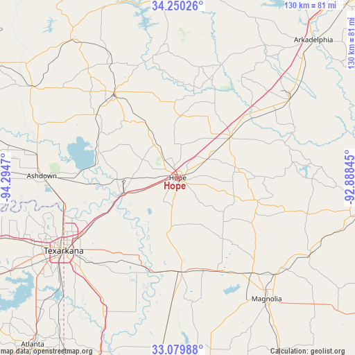
| Map corner | latitude | longitude |
|---|---|---|
| Upper-left | 34.25026°, | -94.2947° |
| Center: | 33.66706°, | -93.59157° |
| Lower-right: | 33.07988°, | -92.88845° |
| Map W x H: | 130.1×130.1 km | = 80.8×80.8mi |
| max Lat: | 71.29058° ⇑82.2% North |
| Hope: | 33.66706° |
| min Lat: | ⇓17.8% South 19.06759° |
| min Long | Hope | max Long |
| -171.73463° | -93.59157° | -66.98998° |
| W 32.3%⇐ | ⇒67.7% E |
Elevation
Elevation of Hope is 112 m = 367 ft, and this is 182.8 m = 600 ft below average elevation for this country.
| Max E: |
3189 m = 10463 ft | 68% |
| Avg. | 294.8 m = 967 ft | |
| Hope | 112 m = 367 ft | |
Min E: |
-60 m = -197 ft | 32% |
See also: United States elevation on elevation.city.
Geographical zone
Hope is located in North temperate zone (between Tropic of Cancer and the Arctic Circle). Distance of this Northern Tropic circle is 1137.5 km =706.8 mi to South.| Distance of | km | miles | from Hope |
|---|---|---|---|
| North Pole | 6263.6 | 3892 | to North |
| Arctic Circle | 3657.7 | 2272.8 | to North |
| Tropic Cancer | 1137.5 | 706.8 | to South |
| Equator | 3743.4 | 2326 | to South |


Nearby cities:
15 places around Hope: (largest is in red/bold)
• Ashdown
50 km =31.1 mi,  270°
270°
• Fouke
52.7 km =32.7 mi,  211°
211°
• Gurdon
49.3 km =30.6 mi,  55°
55°
• Lewisville
34.3 km =21.3 mi,  177°
177°
• Magnolia
55.2 km =34.3 mi,  143°
143°
• Mineral Springs
37.7 km =23.4 mi,  307°
307°
• Murfreesboro
44.9 km =27.9 mi,  348°
348°
• Nash
55.9 km =34.7 mi,  243°
243°
• Nashville
39 km =24.2 mi,  322°
322°
• Prescott
24.6 km =15.3 mi,  52°
52°
• Stamps
34.7 km =21.6 mi,  165°
165°
• Texarkana
48.3 km =30 mi, 238°
• Texarkana
50.1 km =31.1 mi, 237°
• Wake Village
54.7 km =34 mi, 240°
• Waldo
44.5 km =27.7 mi, 141°
Sources, notices
• [Note1] Compared only with cities in United States existing in our database
• [Src1] Map data: © OpenStreetMap contributors (CC-BY-SA)
• [Src2] Other city data from geonames.org with taken over terms of usage.
• [Src3] Geographical zone / Annual Mean Temperature by Robert A. Rohde @ Wikipedia
