Lewisville geodata
Lewisville (Arkansas) is a seat of a second-order administrative division; located in United States in America/Chicago (GMT-5) time zone. With population of 1,181 people, there are 15234 cities with bigger population in this country. Compared to other cities in United States, 83.8% of cities are located further ↑North; 67.7% of cities are located further →East and 70.9% of cities have higher elevation than Lewisville. Note1


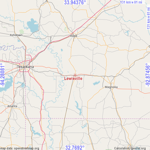
Lewisville GPS coordinates[2]
33° 21' 30.456" North, 93° 34' 39.648" West
| Map corner | latitude | longitude |
|---|---|---|
| Upper-left | 33.94376°, | -94.28081° |
| Center: | 33.35846°, | -93.57768° |
| Lower-right: | 32.7692°, | -92.87456° |
| Map W x H: | 130.6×130.6 km | = 81.2×81.2mi |
| max Lat: | 71.29058° ⇑83.8% North |
| Lewisville: | 33.35846° |
| min Lat: | ⇓16.2% South 19.06759° |
| min Long | Lewisville | max Long |
| -171.73463° | -93.57768° | -66.98998° |
| W 32.3%⇐ | ⇒67.7% E |
Elevation
Elevation of Lewisville is 95 m = 312 ft, and this is 199.8 m = 656 ft below average elevation for this country.
| Max E: |
3189 m = 10463 ft | 70.9% |
| Avg. | 294.8 m = 967 ft | |
| Lewisville | 95 m = 312 ft | |
Min E: |
-60 m = -197 ft | 29.1% |
See also: United States elevation on elevation.city.
Geographical zone
Lewisville is located in North temperate zone (between Tropic of Cancer and the Arctic Circle). Distance of this Northern Tropic circle is 1103.2 km =685.5 mi to South.| Distance of | km | miles | from Lewisville |
|---|---|---|---|
| North Pole | 6297.9 | 3913.3 | to North |
| Arctic Circle | 3692.1 | 2294.2 | to North |
| Tropic Cancer | 1103.2 | 685.5 | to South |
| Equator | 3709.1 | 2304.7 | to South |


Nearby cities:
15 places around Lewisville: (largest is in red/bold)
• Bradley
29.8 km =18.5 mi,  193°
193°
• Cullen
44.9 km =27.9 mi,  164°
164°
• Fouke
30.6 km =19 mi,  249°
249°
• Hope
34.3 km =21.3 mi,  357°
357°
• Magnolia
33 km =20.5 mi,  107°
107°
• Nash
52.2 km =32.4 mi,  280°
280°
• Plain Dealing
51.6 km =32.1 mi, 192°
• Springhill
40.5 km =25.2 mi,  165°
165°
• Stamps
7.7 km =4.8 mi,  84°
84°
• Stephens
47.5 km =29.5 mi, 82°
• Taylor
30.7 km =19.1 mi, 159°
• Texarkana
43.7 km =27.2 mi, 282°
• Texarkana
44.3 km =27.5 mi, 279°
• Wake Village
49.7 km =30.9 mi, 278°
• Waldo
26.2 km =16.3 mi,  91°
91°
Sources, notices
• [Note1] Compared only with cities in United States existing in our database
• [Src1] Map data: © OpenStreetMap contributors (CC-BY-SA)
• [Src2] Other city data from geonames.org with taken over terms of usage.
• [Src3] Geographical zone / Annual Mean Temperature by Robert A. Rohde @ Wikipedia
