Fayetteville geodata
Fayetteville (Arkansas) is a seat of a second-order administrative division; located in United States in America/Chicago (GMT-5) time zone. With population of 82,830 people, there are 472 cities with bigger population in this country. Compared to other cities in United States, 70.1% of cities are located further ↑North; 69% of cities are located further →East and 85.6% of cities have lower elevation than Fayetteville. Note1
Administrative division(s):
- Level 1: Arkansas
- Level 2: Washington County
- Level 3: Township of Fayetteville


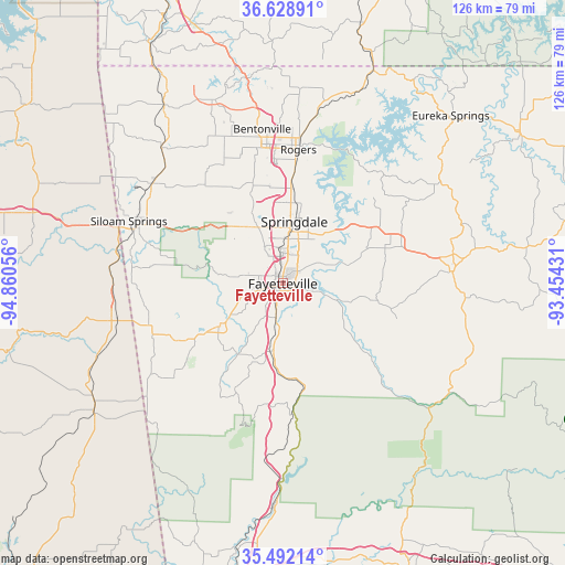
Fayetteville GPS coordinates[2]
36° 3' 45.288" North, 94° 9' 26.748" West
| Map corner | latitude | longitude |
|---|---|---|
| Upper-left | 36.62891°, | -94.86056° |
| Center: | 36.06258°, | -94.15743° |
| Lower-right: | 35.49214°, | -93.45431° |
| Map W x H: | 126.4×126.4 km | = 78.5×78.5mi |
| max Lat: | 71.29058° ⇑70.1% North |
| Fayetteville: | 36.06258° |
| min Lat: | ⇓29.9% South 19.06759° |
| min Long | Fayetteville | max Long |
| -171.73463° | -94.15743° | -66.98998° |
| W 31%⇐ | ⇒69% E |
Elevation
Elevation of Fayetteville is 436 m = 1430 ft, and this is 141.2 m = 463 ft above average elevation for this country.
| Max E: |
3189 m = 10463 ft | 14.4% |
| Fayetteville | 436 m 1430 ft | |
| Avg. | 294.8 m = 967 ft | |
Min E: |
-60 m = -197 ft | 85.6% |
See also: Fayetteville elevation on elevation.city.
Geographical zone
Fayetteville is located in North temperate zone (between Tropic of Cancer and the Arctic Circle). Distance of this Northern Tropic circle is 1403.9 km =872.3 mi to South.| Distance of | km | miles | from Fayetteville |
|---|---|---|---|
| North Pole | 5997.3 | 3726.5 | to North |
| Arctic Circle | 3391.4 | 2107.3 | to North |
| Tropic Cancer | 1403.9 | 872.3 | to South |
| Equator | 4009.8 | 2491.6 | to South |


Nearby cities:
15 places around Fayetteville: (largest is in red/bold)
• Bethel Heights
17.1 km =10.6 mi,  8°
8°
• Cave Springs
23.3 km =14.5 mi,  343°
343°
• Elkins
15 km =9.3 mi,  116°
116°
• Elm Springs
17.4 km =10.8 mi, 336°
• Farmington
8.4 km =5.2 mi,  254°
254°
• Goshen
15.5 km =9.6 mi,  73°
73°
• Greenland
7.8 km =4.8 mi,  191°
191°
• Highfill
28.5 km =17.7 mi,  320°
320°
• Johnson
7.8 km =4.8 mi,  354°
354°
• Lincoln
27 km =16.8 mi,  242°
242°
• Lowell
21.6 km =13.4 mi, 6°
• Prairie Grove
17.3 km =10.7 mi, 236°
• Springdale
14 km =8.7 mi, 10°
• Tontitown
14.5 km =9 mi,  331°
331°
• West Fork
15.6 km =9.7 mi, 190°
Sources, notices
• [Note1] Compared only with cities in United States existing in our database
• [Src1] Map data: © OpenStreetMap contributors (CC-BY-SA)
• [Src2] Other city data from geonames.org with taken over terms of usage.
• [Src3] Geographical zone / Annual Mean Temperature by Robert A. Rohde @ Wikipedia
