Chattahoochee geodata
Chattahoochee (Florida) is a populated place; located in United States in America/New_York (GMT-4) time zone. With population of 3,144 people, there are 9394 cities with bigger population in this country. Compared to other cities in United States, 91.3% of cities are located further ↑North; 56.2% of cities are located further ←West and 73.5% of cities have higher elevation than Chattahoochee. Note1


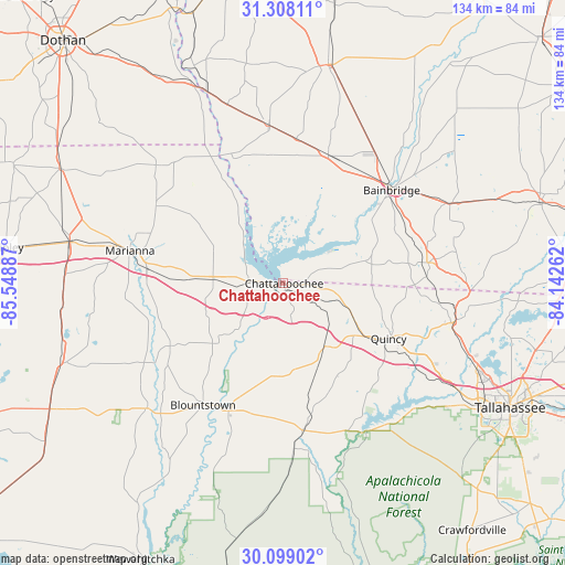
Chattahoochee GPS coordinates[2]
30° 42' 19.656" North, 84° 50' 44.664" West
| Map corner | latitude | longitude |
|---|---|---|
| Upper-left | 31.30811°, | -85.54887° |
| Center: | 30.70546°, | -84.84574° |
| Lower-right: | 30.09902°, | -84.14262° |
| Map W x H: | 134.4×134.4 km | = 83.5×83.5mi |
| max Lat: | 71.29058° ⇑91.3% North |
| Chattahoochee: | 30.70546° |
| min Lat: | ⇓8.7% South 19.06759° |
| min Long | Chattahoochee | max Long |
| -171.73463° | -84.84574° | -66.98998° |
| W 56.2%⇐ | ⇒43.8% E |
Elevation
Elevation of Chattahoochee is 80 m = 262 ft, and this is 214.8 m = 705 ft below average elevation for this country.
| Max E: |
3189 m = 10463 ft | 73.5% |
| Avg. | 294.8 m = 967 ft | |
| Chattahoochee | 80 m = 262 ft | |
Min E: |
-60 m = -197 ft | 26.5% |
See also: United States elevation on elevation.city.
Geographical zone
Chattahoochee is located in North temperate zone (between Tropic of Cancer and the Arctic Circle). Distance of this Northern Tropic circle is 808.2 km =502.2 mi to South.| Distance of | km | miles | from Chattahoochee |
|---|---|---|---|
| North Pole | 6592.9 | 4096.6 | to North |
| Arctic Circle | 3987 | 2477.4 | to North |
| Tropic Cancer | 808.2 | 502.2 | to South |
| Equator | 3414.1 | 2121.4 | to South |


Nearby cities:
15 places around Chattahoochee: (largest is in red/bold)
• Altha
30.8 km =19.1 mi,  240°
240°
• Bainbridge
33.9 km =21.1 mi,  49°
49°
• Blountstown
34.9 km =21.7 mi,  213°
213°
• Bristol
32.9 km =20.4 mi,  202°
202°
• Donalsonville
37.4 km =23.2 mi,  355°
355°
• Grand Ridge
17 km =10.6 mi,  272°
272°
• Greensboro
17.9 km =11.1 mi,  147°
147°
• Greenwood
35.3 km =21.9 mi,  301°
301°
• Gretna
20.3 km =12.6 mi,  118°
118°
• Havana
42.2 km =26.2 mi,  102°
102°
• Hosford
35.7 km =22.2 mi,  172°
172°
• Malone
41.2 km =25.6 mi,  312°
312°
• Marianna
37.2 km =23.1 mi,  281°
281°
• Quincy
28.3 km =17.6 mi, 117°
• Sneads
7.6 km =4.7 mi, 272°
Sources, notices
• [Note1] Compared only with cities in United States existing in our database
• [Src1] Map data: © OpenStreetMap contributors (CC-BY-SA)
• [Src2] Other city data from geonames.org with taken over terms of usage.
• [Src3] Geographical zone / Annual Mean Temperature by Robert A. Rohde @ Wikipedia
