Bainbridge geodata
Bainbridge (Georgia) is a seat of a second-order administrative division; located in United States in America/New_York (GMT-4) time zone. With population of 12,507 people, there are 3773 cities with bigger population in this country. Compared to other cities in United States, 90.9% of cities are located further ↑North; 57.1% of cities are located further ←West and 80.3% of cities have higher elevation than Bainbridge. Note1


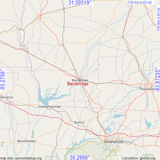
Bainbridge GPS coordinates[2]
30° 54' 13.68" North, 84° 34' 31.692" West
| Map corner | latitude | longitude |
|---|---|---|
| Upper-left | 31.50519°, | -85.2786° |
| Center: | 30.9038°, | -84.57547° |
| Lower-right: | 30.2986°, | -83.87235° |
| Map W x H: | 134.2×134.2 km | = 83.4×83.4mi |
| max Lat: | 71.29058° ⇑90.9% North |
| Bainbridge: | 30.9038° |
| min Lat: | ⇓9.1% South 19.06759° |
| min Long | Bainbridge | max Long |
| -171.73463° | -84.57547° | -66.98998° |
| W 57.1%⇐ | ⇒42.9% E |
Elevation
Elevation of Bainbridge is 45 m = 148 ft, and this is 249.8 m = 820 ft below average elevation for this country.
| Max E: |
3189 m = 10463 ft | 80.3% |
| Avg. | 294.8 m = 967 ft | |
| Bainbridge | 45 m = 148 ft | |
Min E: |
-60 m = -197 ft | 19.7% |
See also: United States elevation on elevation.city.
Geographical zone
Bainbridge is located in North temperate zone (between Tropic of Cancer and the Arctic Circle). Distance of this Northern Tropic circle is 830.3 km =515.9 mi to South.| Distance of | km | miles | from Bainbridge |
|---|---|---|---|
| North Pole | 6570.9 | 4083 | to North |
| Arctic Circle | 3965 | 2463.7 | to North |
| Tropic Cancer | 830.3 | 515.9 | to South |
| Equator | 3436.2 | 2135.2 | to South |


Nearby cities:
15 places around Bainbridge: (largest is in red/bold)
• Cairo
35.7 km =22.2 mi,  94°
94°
• Camilla
50.3 km =31.3 mi,  43°
43°
• Chattahoochee
33.9 km =21.1 mi,  229°
229°
• Colquitt
33.3 km =20.7 mi,  333°
333°
• Donalsonville
32.7 km =20.3 mi,  297°
297°
• Grand Ridge
47.7 km =29.6 mi,  243°
243°
• Greensboro
40.5 km =25.2 mi,  203°
203°
• Gretna
32.9 km =20.4 mi,  194°
194°
• Havana
34.7 km =21.6 mi,  153°
153°
• Meigs
50 km =31.1 mi,  67°
67°
• Midway
46.9 km =29.1 mi,  165°
165°
• Ochlocknee
50.2 km =31.2 mi,  81°
81°
• Pelham
47.3 km =29.4 mi,  58°
58°
• Quincy
35.2 km =21.9 mi,  181°
181°
• Sneads
39.9 km =24.8 mi, 236°
Sources, notices
• [Note1] Compared only with cities in United States existing in our database
• [Src1] Map data: © OpenStreetMap contributors (CC-BY-SA)
• [Src2] Other city data from geonames.org with taken over terms of usage.
• [Src3] Geographical zone / Annual Mean Temperature by Robert A. Rohde @ Wikipedia
