Greensboro geodata
Greensboro (Florida) is a populated place; located in United States in America/New_York (GMT-4) time zone. With population of 605 people, there are 19636 cities with bigger population in this country. Compared to other cities in United States, 91.6% of cities are located further ↑North; 56.5% of cities are located further ←West and 72% of cities have higher elevation than Greensboro. Note1


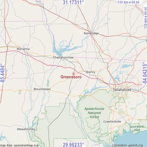
Greensboro GPS coordinates[2]
30° 34' 10.596" North, 84° 44' 42.972" West
| Map corner | latitude | longitude |
|---|---|---|
| Upper-left | 31.17311°, | -85.4484° |
| Center: | 30.56961°, | -84.74527° |
| Lower-right: | 29.96233°, | -84.04215° |
| Map W x H: | 134.6×134.6 km | = 83.6×83.6mi |
| max Lat: | 71.29058° ⇑91.6% North |
| Greensboro: | 30.56961° |
| min Lat: | ⇓8.4% South 19.06759° |
| min Long | Greensboro | max Long |
| -171.73463° | -84.74527° | -66.98998° |
| W 56.5%⇐ | ⇒43.5% E |
Elevation
Elevation of Greensboro is 89 m = 292 ft, and this is 205.8 m = 675 ft below average elevation for this country.
| Max E: |
3189 m = 10463 ft | 72% |
| Avg. | 294.8 m = 967 ft | |
| Greensboro | 89 m = 292 ft | |
Min E: |
-60 m = -197 ft | 28% |
See also: United States elevation on elevation.city.
Geographical zone
Greensboro is located in North temperate zone (between Tropic of Cancer and the Arctic Circle). Distance of this Northern Tropic circle is 793.1 km =492.8 mi to South.| Distance of | km | miles | from Greensboro |
|---|---|---|---|
| North Pole | 6608 | 4106 | to North |
| Arctic Circle | 4002.2 | 2486.9 | to North |
| Tropic Cancer | 793.1 | 492.8 | to South |
| Equator | 3399 | 2112 | to South |


Nearby cities:
15 places around Greensboro: (largest is in red/bold)
• Altha
36.6 km =22.7 mi,  270°
270°
• Bainbridge
40.5 km =25.2 mi,  23°
23°
• Blountstown
32.2 km =20 mi,  244°
244°
• Bristol
26.9 km =16.7 mi, 235°
• Chattahoochee
17.9 km =11.1 mi,  327°
327°
• Grand Ridge
31 km =19.3 mi,  300°
300°
• Greenwood
52 km =32.3 mi,  310°
310°
• Gretna
9.7 km =6 mi,  57°
57°
• Havana
32.2 km =20 mi,  79°
79°
• Hosford
21 km =13 mi,  194°
194°
• Marianna
51.4 km =31.9 mi, 296°
• Midway
29.1 km =18.1 mi,  106°
106°
• Quincy
15.6 km =9.7 mi, 82°
• Sneads
23.1 km =14.4 mi, 311°
• Tallahassee
46.8 km =29.1 mi, 108°
Sources, notices
• [Note1] Compared only with cities in United States existing in our database
• [Src1] Map data: © OpenStreetMap contributors (CC-BY-SA)
• [Src2] Other city data from geonames.org with taken over terms of usage.
• [Src3] Geographical zone / Annual Mean Temperature by Robert A. Rohde @ Wikipedia
