Havana geodata
Havana (Florida) is a populated place; located in United States in America/New_York (GMT-4) time zone. With population of 1,688 people, there are 12953 cities with bigger population in this country. Compared to other cities in United States, 91.4% of cities are located further ↑North; 57.7% of cities are located further ←West and 73.3% of cities have higher elevation than Havana. Note1


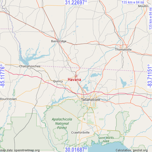
Havana GPS coordinates[2]
30° 37' 25.716" North, 84° 24' 52.668" West
| Map corner | latitude | longitude |
|---|---|---|
| Upper-left | 31.22697°, | -85.11776° |
| Center: | 30.62381°, | -84.41463° |
| Lower-right: | 30.01687°, | -83.71151° |
| Map W x H: | 134.6×134.6 km | = 83.6×83.6mi |
| max Lat: | 71.29058° ⇑91.4% North |
| Havana: | 30.62381° |
| min Lat: | ⇓8.6% South 19.06759° |
| min Long | Havana | max Long |
| -171.73463° | -84.41463° | -66.98998° |
| W 57.7%⇐ | ⇒42.3% E |
Elevation
Elevation of Havana is 81 m = 266 ft, and this is 213.8 m = 701 ft below average elevation for this country.
| Max E: |
3189 m = 10463 ft | 73.3% |
| Avg. | 294.8 m = 967 ft | |
| Havana | 81 m = 266 ft | |
Min E: |
-60 m = -197 ft | 26.7% |
See also: United States elevation on elevation.city.
Geographical zone
Havana is located in North temperate zone (between Tropic of Cancer and the Arctic Circle). Distance of this Northern Tropic circle is 799.1 km =496.5 mi to South.| Distance of | km | miles | from Havana |
|---|---|---|---|
| North Pole | 6602 | 4102.3 | to North |
| Arctic Circle | 3996.1 | 2483.1 | to North |
| Tropic Cancer | 799.1 | 496.5 | to South |
| Equator | 3405 | 2115.8 | to South |


Nearby cities:
15 places around Havana: (largest is in red/bold)
• Bainbridge
34.7 km =21.6 mi,  333°
333°
• Cairo
34.8 km =21.6 mi,  35°
35°
• Chattahoochee
42.2 km =26.2 mi,  282°
282°
• Crawfordville
49.9 km =31 mi,  175°
175°
• Greensboro
32.2 km =20 mi,  259°
259°
• Gretna
23.5 km =14.6 mi,  268°
268°
• Hosford
45.3 km =28.1 mi,  234°
234°
• Midway
14.8 km =9.2 mi,  194°
194°
• Monticello
52.7 km =32.7 mi,  99°
99°
• Ochlocknee
51.9 km =32.2 mi, 41°
• Quincy
16.6 km =10.3 mi, 255°
• Sneads
49.8 km =30.9 mi, 280°
• Tallahassee
24.3 km =15.1 mi,  148°
148°
• Thomasville
47.9 km =29.8 mi,  60°
60°
• Woodville
38 km =23.6 mi,  155°
155°
Sources, notices
• [Note1] Compared only with cities in United States existing in our database
• [Src1] Map data: © OpenStreetMap contributors (CC-BY-SA)
• [Src2] Other city data from geonames.org with taken over terms of usage.
• [Src3] Geographical zone / Annual Mean Temperature by Robert A. Rohde @ Wikipedia
