Donalsonville geodata
Donalsonville (Georgia) is a seat of a second-order administrative division; located in United States in America/New_York (GMT-4) time zone. With population of 2,675 people, there are 10227 cities with bigger population in this country. Compared to other cities in United States, 90.7% of cities are located further ↑North; 56.1% of cities are located further ←West and 79% of cities have higher elevation than Donalsonville. Note1


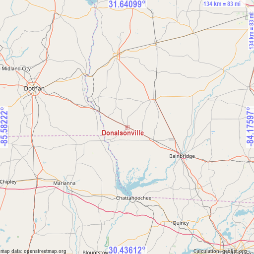
Donalsonville GPS coordinates[2]
31° 2' 25.656" North, 84° 52' 44.724" West
| Map corner | latitude | longitude |
|---|---|---|
| Upper-left | 31.64099°, | -85.58222° |
| Center: | 31.04046°, | -84.87909° |
| Lower-right: | 30.43612°, | -84.17597° |
| Map W x H: | 134×134 km | = 83.3×83.3mi |
| max Lat: | 71.29058° ⇑90.7% North |
| Donalsonville: | 31.04046° |
| min Lat: | ⇓9.3% South 19.06759° |
| min Long | Donalsonville | max Long |
| -171.73463° | -84.87909° | -66.98998° |
| W 56.1%⇐ | ⇒43.9% E |
Elevation
Elevation of Donalsonville is 51 m = 167 ft, and this is 243.8 m = 800 ft below average elevation for this country.
| Max E: |
3189 m = 10463 ft | 79% |
| Avg. | 294.8 m = 967 ft | |
| Donalsonville | 51 m = 167 ft | |
Min E: |
-60 m = -197 ft | 21% |
See also: United States elevation on elevation.city.
Geographical zone
Donalsonville is located in North temperate zone (between Tropic of Cancer and the Arctic Circle). Distance of this Northern Tropic circle is 845.5 km =525.4 mi to South.| Distance of | km | miles | from Donalsonville |
|---|---|---|---|
| North Pole | 6555.7 | 4073.5 | to North |
| Arctic Circle | 3949.8 | 2454.3 | to North |
| Tropic Cancer | 845.5 | 525.4 | to South |
| Equator | 3451.4 | 2144.6 | to South |


Nearby cities:
15 places around Donalsonville: (largest is in red/bold)
• Ashford
37.5 km =23.3 mi,  294°
294°
• Avon
42.1 km =26.2 mi, 293°
• Bainbridge
32.7 km =20.3 mi,  117°
117°
• Blakely
37.9 km =23.5 mi,  352°
352°
• Chattahoochee
37.4 km =23.2 mi,  175°
175°
• Colquitt
20.1 km =12.5 mi,  43°
43°
• Columbia
35.8 km =22.2 mi,  321°
321°
• Cottonwood
40.6 km =25.2 mi,  271°
271°
• Cowarts
44.2 km =27.5 mi, 293°
• Grand Ridge
38.9 km =24.2 mi,  200°
200°
• Greenwood
32.9 km =20.4 mi,  234°
234°
• Malone
28.5 km =17.7 mi,  251°
251°
• Marianna
44.5 km =27.7 mi, 228°
• Sneads
37.2 km =23.1 mi,  186°
186°
• Webb
44.8 km =27.8 mi,  303°
303°
Sources, notices
• [Note1] Compared only with cities in United States existing in our database
• [Src1] Map data: © OpenStreetMap contributors (CC-BY-SA)
• [Src2] Other city data from geonames.org with taken over terms of usage.
• [Src3] Geographical zone / Annual Mean Temperature by Robert A. Rohde @ Wikipedia
