Tallahassee geodata
Tallahassee (Florida) is a seat of a first-order administrative division; located in United States in America/New_York (GMT-4) time zone. With population of 189,907 people, there are 138 cities with bigger population in this country. Compared to other cities in United States, 92% of cities are located further ↑North; 58.4% of cities are located further ←West and 75.1% of cities have higher elevation than Tallahassee. Note1


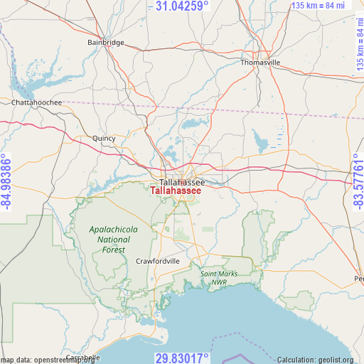
Tallahassee GPS coordinates[2]
30° 26' 17.736" North, 84° 16' 50.628" West
| Map corner | latitude | longitude |
|---|---|---|
| Upper-left | 31.04259°, | -84.98386° |
| Center: | 30.43826°, | -84.28073° |
| Lower-right: | 29.83017°, | -83.57761° |
| Map W x H: | 134.8×134.8 km | = 83.8×83.8mi |
| max Lat: | 71.29058° ⇑92% North |
| Tallahassee: | 30.43826° |
| min Lat: | ⇓8% South 19.06759° |
| min Long | Tallahassee | max Long |
| -171.73463° | -84.28073° | -66.98998° |
| W 58.4%⇐ | ⇒41.6% E |
Elevation
Elevation of Tallahassee is 71 m = 233 ft, and this is 223.8 m = 734 ft below average elevation for this country.
| Max E: |
3189 m = 10463 ft | 75.1% |
| Avg. | 294.8 m = 967 ft | |
| Tallahassee | 71 m = 233 ft | |
Min E: |
-60 m = -197 ft | 24.9% |
See also: Tallahassee elevation on elevation.city.
Geographical zone
Tallahassee is located in North temperate zone (between Tropic of Cancer and the Arctic Circle). Distance of this Northern Tropic circle is 778.5 km =483.7 mi to South.| Distance of | km | miles | from Tallahassee |
|---|---|---|---|
| North Pole | 6622.6 | 4115.1 | to North |
| Arctic Circle | 4016.8 | 2495.9 | to North |
| Tropic Cancer | 778.5 | 483.7 | to South |
| Equator | 3384.4 | 2103 | to South |


Nearby cities:
15 places around Tallahassee: (largest is in red/bold)
• Bainbridge
58.9 km =36.6 mi,  331°
331°
• Boston
61.3 km =38.1 mi,  50°
50°
• Cairo
49.4 km =30.7 mi,  8°
8°
• Chattahoochee
61.7 km =38.3 mi,  298°
298°
• Crawfordville
30.5 km =19 mi,  197°
197°
• Greensboro
46.8 km =29.1 mi,  288°
288°
• Gretna
41.4 km =25.7 mi, 298°
• Havana
24.3 km =15.1 mi, 328°
• Hosford
50.1 km =31.1 mi,  263°
263°
• Midway
17.8 km =11.1 mi, 290°
• Monticello
41 km =25.5 mi,  73°
73°
• Panacea
45.7 km =28.4 mi,  192°
192°
• Quincy
33.4 km =20.8 mi, 299°
• Thomasville
52.9 km =32.9 mi,  33°
33°
• Woodville
14.2 km =8.8 mi,  166°
166°
Sources, notices
• [Note1] Compared only with cities in United States existing in our database
• [Src1] Map data: © OpenStreetMap contributors (CC-BY-SA)
• [Src2] Other city data from geonames.org with taken over terms of usage.
• [Src3] Geographical zone / Annual Mean Temperature by Robert A. Rohde @ Wikipedia
